Tlahuelilpan night lights from space
Night Light of Tlahuelilpan (Hidalgo) from space (Mexico) Src. Average luminocity for 10x10km area is 46.2619% and for 50x50km: 25.6676%.
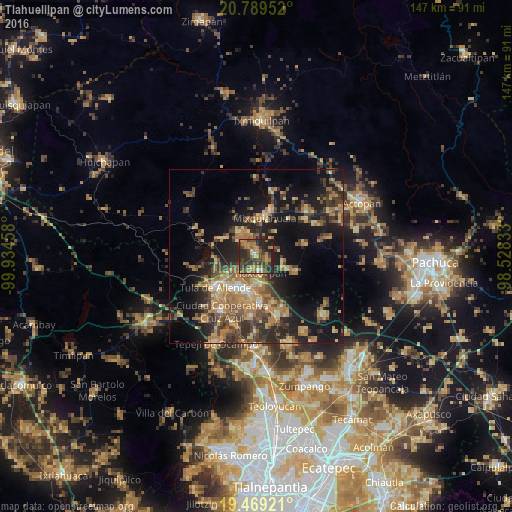
Analysis of Tlahuelilpan night lights 2016
Square area 10x10 km:
 0.79%
0.79%90-99
2.38%80-89
2.78%70-79
10.91%60-69
16.27%50-59
5.75%40-49
14.48%30-39
17.26%20-29
23.81%10-19
5.56%0-9
0%Square area 50x50 km:
0.77%90-99
1.37%80-89
3.74%70-79
4.61%60-69
7.31%50-59
3.75%40-49
5.82%30-39
5.74%20-29
8.16%10-19
17.76%0-9
40.98%Clear (daylight) street map image can be seen on geolist.org.
Map coordinates:
20° 47' 22.3" North, 99° 56' 4.5" West
20° 7' 50.7" North, 99° 13' 53.2" West
19° 28' 9.2" North, 98° 31' 42" West
Some cities around Tlahuelilpan sort by population:
• Mixquiahuala de Juarez
11.2 km =7 mi,  9°
9°
• Tlaxcoapan
4.5 km =2.8 mi,  165°
165°
• Cardonal
8.2 km =5.1 mi,  179°
179°
• Tetepango
9 km =5.6 mi,  111°
111°
• Doxey
4.5 km =2.8 mi,  196°
196°
• Presas
3.9 km =2.4 mi,  325°
325°
• Atitalaquia
8 km =5 mi, 172°
• Huitel
6.4 km =4 mi,  309°
309°
3515459 (p: 8,498)
Sources (retrieved 2019-11-25):
» Earth at Night: Flat Maps 2012, 2016