Atitalaquia night lights from space
Night Light of Atitalaquia (Hidalgo) from space (Mexico) Src. Average luminocity for 10x10km area is 61.1865% and for 50x50km: 30.8244%.
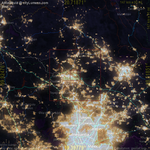
Analysis of Atitalaquia night lights 2016
Square area 10x10 km:
 3.57%
3.57%90-99
8.33%80-89
11.31%70-79
13.29%60-69
20.04%50-59
11.71%40-49
10.71%30-39
6.75%20-29
13.29%10-19
0.99%0-9
0%Square area 50x50 km:
1.17%90-99
1.9%80-89
4.57%70-79
5.64%60-69
8.57%50-59
4.62%40-49
6.88%30-39
7.66%20-29
10.3%10-19
17.72%0-9
30.96%Clear (daylight) street map image can be seen on geolist.org.
Map coordinates:
20° 43' 7.4" North, 99° 55' 29.1" West
20° 3' 34.7" North, 99° 13' 17.9" West
19° 23' 52" North, 98° 31' 6.6" West
Some cities around Atitalaquia sort by population:
• El Llano
10.3 km =6.4 mi,  273°
273°
• Tlaxcoapan
3.6 km =2.2 mi,  2°
2°
• Apaxco de Ocampo
10.8 km =6.7 mi,  150°
150°
• Cardonal
1 km =0.6 mi,  251°
251°
• Tetepango
8.7 km =5.4 mi,  57°
57°
• Tlahuelilpan
8 km =5 mi,  352°
352°
• Atotonilco de Tula
5.8 km =3.6 mi,  176°
176°
• Doxey
4.2 km =2.6 mi,  327°
327°
3532627 (p: 6,322)
Sources (retrieved 2019-11-25):
» Earth at Night: Flat Maps 2012, 2016