Huitel night lights from space
Night Light of Huitel (Hidalgo) from space (Mexico) Src. Average luminocity for 10x10km area is 40.4286% and for 50x50km: 22.0771%.
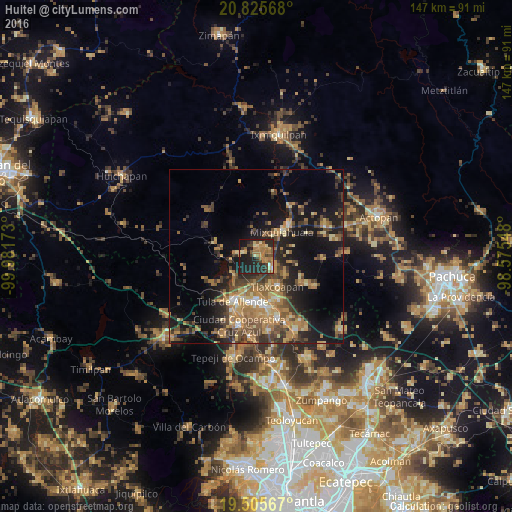
Analysis of Huitel night lights 2016
Square area 10x10 km:
 0.6%
0.6%90-99
1.98%80-89
6.94%70-79
7.14%60-69
15.67%50-59
5.36%40-49
4.17%30-39
6.94%20-29
20.83%10-19
28.77%0-9
1.59%Square area 50x50 km:
0.74%90-99
1.26%80-89
3.1%70-79
4.05%60-69
6.3%50-59
3.26%40-49
4.9%30-39
4.83%20-29
6.2%10-19
15.07%0-9
50.28%Clear (daylight) street map image can be seen on geolist.org.
Map coordinates:
20° 49' 32.4" North, 99° 58' 54.2" West
20° 10' 1.5" North, 99° 16' 43" West
19° 30' 20.4" North, 98° 34' 31.7" West
Some cities around Huitel sort by population:
• Mixquiahuala de Juarez
9.7 km =6 mi,  43°
43°
• Progreso de Alvaro Obregon
13 km =8.1 mi,  45°
45°
• El Llano
12.1 km =7.5 mi,  200°
200°
• Tlaxcoapan
10.4 km =6.5 mi,  144°
144°
• Tlahuelilpan
6.4 km =4 mi,  129°
129°
• Doxey
9.1 km =5.7 mi,  156°
156°
• Presas
2.9 km =1.8 mi,  107°
107°
• Atitalaquia
13.3 km =8.3 mi,  153°
153°
3814127 (p: 5,390)
Sources (retrieved 2019-11-25):
» Earth at Night: Flat Maps 2012, 2016