Tetepango night lights from space
Night Light of Tetepango (Hidalgo) from space (Mexico) Src. Average luminocity for 10x10km area is 25.5992% and for 50x50km: 30.3307%.
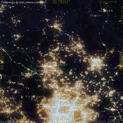
Analysis of Tetepango night lights 2016
Square area 10x10 km:
 0%
0%90-99
0.6%80-89
4.37%70-79
2.38%60-69
8.53%50-59
0.4%40-49
6.55%30-39
4.37%20-29
14.88%10-19
31.75%0-9
26.19%Square area 50x50 km:
0.96%90-99
1.64%80-89
4.7%70-79
5.72%60-69
8.54%50-59
4.27%40-49
6.65%30-39
6.74%20-29
10.78%10-19
19.76%0-9
30.24%Clear (daylight) street map image can be seen on geolist.org.
Map coordinates:
20° 45' 38.1" North, 99° 51' 15.2" West
20° 6' 6" North, 99° 9' 3.9" West
19° 26' 24" North, 98° 26' 52.7" West
Some cities around Tetepango sort by population:
• Tlaxcoapan
7.3 km =4.5 mi,  261°
261°
• Cardonal
9.7 km =6 mi,  238°
238°
• Tlahuelilpan
9 km =5.6 mi,  291°
291°
• Atotonilco de Tula
12.6 km =7.8 mi,  213°
213°
• Ajacuba
3.2 km =2 mi,  110°
110°
• Doxey
9.7 km =6 mi, 263°
• Presas
12.4 km =7.7 mi,  301°
301°
• Atitalaquia
8.7 km =5.4 mi, 237°
3515751 (p: 8,705)
Sources (retrieved 2019-11-25):
» Earth at Night: Flat Maps 2012, 2016