Presas night lights from space
Night Light of Presas (Hidalgo) from space (Mexico) Src. Average luminocity for 10x10km area is 44.7758% and for 50x50km: 23.3854%.
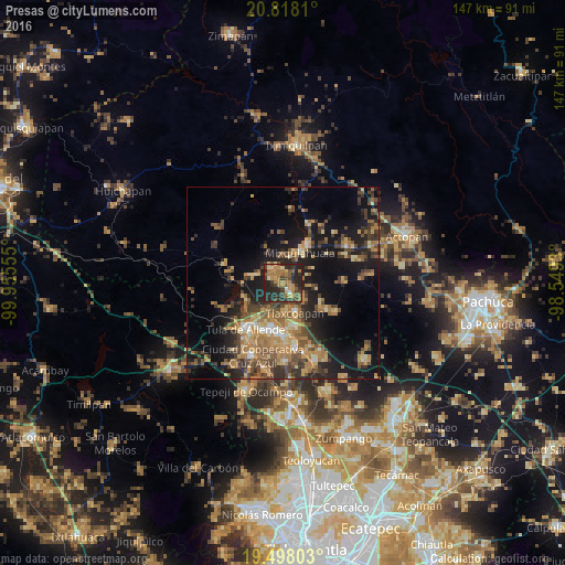
Analysis of Presas night lights 2016
Square area 10x10 km:
 0.6%
0.6%90-99
1.59%80-89
4.37%70-79
10.52%60-69
16.47%50-59
7.54%40-49
7.74%30-39
12.9%20-29
30.75%10-19
7.54%0-9
0%Square area 50x50 km:
0.74%90-99
1.27%80-89
3.25%70-79
4.2%60-69
6.8%50-59
3.38%40-49
5.25%30-39
5.36%20-29
6.86%10-19
16.07%0-9
46.81%Clear (daylight) street map image can be seen on geolist.org.
Map coordinates:
20° 49' 5.2" North, 99° 57' 20" West
20° 9' 34.1" North, 99° 15' 8.7" West
19° 29' 52.9" North, 98° 32' 57.5" West
Some cities around Presas sort by population:
• Mixquiahuala de Juarez
8.8 km =5.5 mi,  26°
26°
• Progreso de Alvaro Obregon
11.9 km =7.4 mi, 33°
• Tlaxcoapan
8.2 km =5.1 mi,  156°
156°
• Cardonal
11.6 km =7.2 mi,  168°
168°
• Tlahuelilpan
3.9 km =2.4 mi,  145°
145°
• Doxey
7.6 km =4.7 mi, 173°
• Atitalaquia
11.6 km =7.2 mi, 163°
• Huitel
2.9 km =1.8 mi,  287°
287°
3814128 (p: 6,942)
Sources (retrieved 2019-11-25):
» Earth at Night: Flat Maps 2012, 2016