Tizapán el Alto night lights from space
Night Light of Tizapán el Alto (Jalisco) from space (Mexico) Src. Average luminocity for 10x10km area is 8.4365% and for 50x50km: 4.797%.
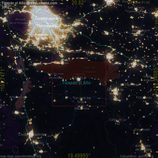
Analysis of Tizapán el Alto night lights 2016
Square area 10x10 km:
 0%
0%90-99
0.4%80-89
4.37%70-79
0.4%60-69
2.38%50-59
0%40-49
0.79%30-39
0%20-29
1.19%10-19
0.4%0-9
90.08%Square area 50x50 km:
0.03%90-99
0.16%80-89
0.71%70-79
1.02%60-69
0.86%50-59
0.55%40-49
1.11%30-39
0.81%20-29
0.95%10-19
4.48%0-9
89.32%Clear (daylight) street map image can be seen on geolist.org.
Map coordinates:
20° 49' 12" North, 103° 44' 49.6" West
20° 9' 40.9" North, 103° 2' 38.3" West
19° 29' 59.8" North, 102° 20' 27.1" West
Some cities around Tizapán el Alto sort by population:
• Chapala
21.5 km =13.4 mi,  314°
314°
• Ajijic
27.1 km =16.8 mi, 305°
• San José de Gracia
19.2 km =11.9 mi,  173°
173°
• Atotonilquillo
27 km =16.8 mi,  342°
342°
• Cojumatlán de Régules
20.6 km =12.8 mi,  103°
103°
• Ixtlahuacán de los Membrillos
26 km =16.2 mi,  323°
323°
• San Pedro Itzicán
19.7 km =12.2 mi,  28°
28°
• Mezcala
19.6 km =12.2 mi,  8°
8°
3981491 (p: 14,877)
Sources (retrieved 2019-11-25):
» Earth at Night: Flat Maps 2012, 2016