Tepalcatepec night lights from space
Night Light of Tepalcatepec (Michoacán) from space (Mexico) Src. Average luminocity for 10x10km area is 9.855% and for 50x50km: 1.3011%.
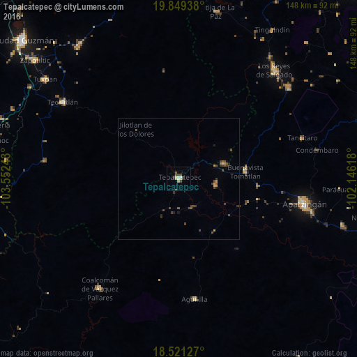
Analysis of Tepalcatepec night lights 2016
Square area 10x10 km:
 0%
0%90-99
2.38%80-89
0.22%70-79
3.46%60-69
0%50-59
1.3%40-49
1.73%30-39
3.03%20-29
2.16%10-19
0%0-9
85.71%Square area 50x50 km:
0.02%90-99
0.1%80-89
0.06%70-79
0.3%60-69
0.07%50-59
0.26%40-49
0.61%30-39
0.41%20-29
0.23%10-19
0.14%0-9
97.79%Clear (daylight) street map image can be seen on geolist.org.
Map coordinates:
19° 50' 57.8" North, 103° 33' 8.7" West
19° 11' 12" North, 102° 50' 57.5" West
18° 31' 16.6" North, 102° 8' 46.2" West
Some cities around Tepalcatepec sort by population:
• Apatzingán
52.8 km =32.8 mi,  101°
101°
• Tecalitlán
57.6 km =35.8 mi,  303°
303°
• Coalcomán de Vázquez Pallares
56 km =34.8 mi,  215°
215°
• Buenavista Tomatlán
27.7 km =17.2 mi,  83°
83°
• Felipe Carrillo Puerto
15 km =9.3 mi, 99°
• Aguililla
50.3 km =31.3 mi,  172°
172°
• Pihuamo
56.4 km =35 mi,  277°
277°
• Tancítaro
53.8 km =33.4 mi,  71°
71°
3982007 (p: 15,221)
Sources (retrieved 2019-11-25):
» Earth at Night: Flat Maps 2012, 2016