Tecalitlán night lights from space
Night Light of Tecalitlán (Jalisco) from space (Mexico) Src. Average luminocity for 10x10km area is 9.9463% and for 50x50km: 3.6946%.
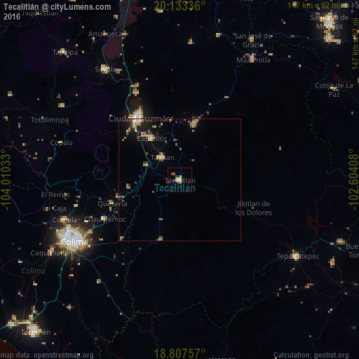
Analysis of Tecalitlán night lights 2016
Square area 10x10 km:
 0%
0%90-99
2.27%80-89
2.69%70-79
0.83%60-69
0.83%50-59
0.83%40-49
2.48%30-39
1.24%20-29
1.45%10-19
1.03%0-9
86.36%Square area 50x50 km:
0.09%90-99
0.24%80-89
0.8%70-79
0.58%60-69
0.55%50-59
0.51%40-49
0.77%30-39
0.54%20-29
0.67%10-19
2.23%0-9
93.02%Clear (daylight) street map image can be seen on geolist.org.
Map coordinates:
20° 8' 0.1" North, 104° 0' 37.2" West
19° 28' 18.6" North, 103° 18' 25.9" West
18° 48' 27.3" North, 102° 36' 14.7" West
Some cities around Tecalitlán sort by population:
• Ciudad Guzmán
30.5 km =19 mi,  327°
327°
• Tuxpan
11.8 km =7.3 mi,  322°
322°
• Zapotiltic
20.8 km =12.9 mi, 326°
• Tamazula de Gordiano
23.9 km =14.9 mi,  14°
14°
• Quesería
29.4 km =18.3 mi,  251°
251°
• Cuauhtémoc
34.9 km =21.7 mi,  242°
242°
• Pihuamo
25.9 km =16.1 mi,  197°
197°
• Cofradía
25.8 km =16 mi,  260°
260°
3982269 (p: 12,411)
Sources (retrieved 2019-11-25):
» Earth at Night: Flat Maps 2012, 2016