San Matias Tlalancaleca night lights from space
Night Light of San Matias Tlalancaleca (Puebla) from space (Mexico) Src. Average luminocity for 10x10km area is 42.3574% and for 50x50km: 24.257%.
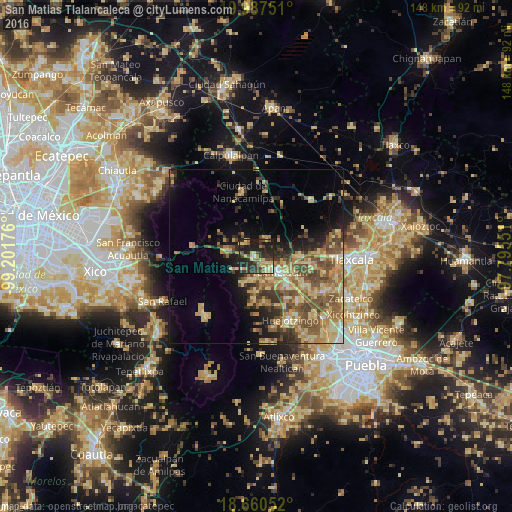
Analysis of San Matias Tlalancaleca night lights 2016
Square area 10x10 km:
 0.41%
0.41%90-99
2.48%80-89
12.6%70-79
7.23%60-69
6.61%50-59
3.72%40-49
9.92%30-39
10.33%20-29
27.27%10-19
19.42%0-9
0%Square area 50x50 km:
0.6%90-99
1.45%80-89
6.83%70-79
4.5%60-69
5.04%50-59
4.76%40-49
5.49%30-39
3.65%20-29
4.52%10-19
7.68%0-9
55.48%Clear (daylight) street map image can be seen on geolist.org.
Map coordinates:
19° 59' 15" North, 99° 12' 6.3" West
19° 19' 31.3" North, 98° 29' 55.1" West
18° 39' 37.9" North, 97° 47' 43.8" West
Some cities around San Matias Tlalancaleca sort by population:
• Moyotzingo
13.1 km =8.1 mi,  131°
131°
• San Rafael Tlanalapan
4.9 km =3 mi,  139°
139°
• San Lucas el Grande
3 km =1.9 mi, 135°
• Santa Rita Tlahuapan
8.2 km =5.1 mi,  275°
275°
• Villa Mariano Matamoros
12.6 km =7.8 mi,  89°
89°
• San Juan Tuxco
8.8 km =5.5 mi,  146°
146°
• Teotlaltzingo
10.5 km =6.5 mi,  181°
181°
• Villa Alta
10.9 km =6.8 mi,  109°
109°
3518352 (p: 11,076)
Sources (retrieved 2019-11-25):
» Earth at Night: Flat Maps 2012, 2016