Tempoal de Sánchez night lights from space
Night Light of Tempoal de Sánchez (Veracruz) from space (Mexico) Src. Average luminocity for 10x10km area is 4.267% and for 50x50km: 1.1761%.
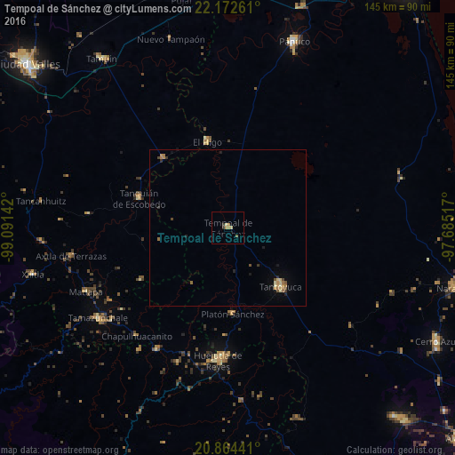
Analysis of Tempoal de Sánchez night lights 2016
Square area 10x10 km:
 0%
0%90-99
0.19%80-89
1.33%70-79
1.33%60-69
0.95%50-59
0.57%40-49
0.19%30-39
1.33%20-29
0.19%10-19
0%0-9
93.94%Square area 50x50 km:
0%90-99
0.08%80-89
0.21%70-79
0.22%60-69
0.38%50-59
0.14%40-49
0.15%30-39
0.17%20-29
0.17%10-19
0.26%0-9
98.22%Clear (daylight) street map image can be seen on geolist.org.
Map coordinates:
22° 10' 21.4" North, 99° 5' 29.1" West
21° 31' 11.9" North, 98° 23' 17.8" West
20° 51' 51.9" North, 97° 41' 6.6" West
Some cities around Tempoal de Sánchez sort by population:
• Huejutla de Reyes
42.4 km =26.3 mi,  184°
184°
• Tantoyuca
25.3 km =15.7 mi,  138°
138°
• Platón Sánchez
27.6 km =17.1 mi, 177°
• Tanquián de Escobedo
29.9 km =18.6 mi,  288°
288°
• El Higo
28.2 km =17.5 mi,  346°
346°
• San Felipe Orizatlán
44.9 km =27.9 mi,  210°
210°
• San Vicente Tancuayalab
30.2 km =18.8 mi,  317°
317°
• Jaltocan
45.8 km =28.5 mi,  199°
199°
3516019 (p: 12,526)
Sources (retrieved 2019-11-25):
» Earth at Night: Flat Maps 2012, 2016