San Andrés Ixtlán night lights from space
Night Light of San Andrés Ixtlán (Jalisco) from space (Mexico) Src. Average luminocity for 10x10km area is 10.4752% and for 50x50km: 4.8756%.
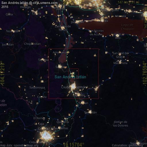
Analysis of San Andrés Ixtlán night lights 2016
Square area 10x10 km:
 0%
0%90-99
0%80-89
1.03%70-79
2.07%60-69
4.34%50-59
2.48%40-49
2.07%30-39
2.07%20-29
0%10-19
0.83%0-9
85.12%Square area 50x50 km:
0.25%90-99
0.39%80-89
0.82%70-79
0.79%60-69
0.73%50-59
0.73%40-49
0.8%30-39
0.68%20-29
0.89%10-19
3.51%0-9
90.41%Clear (daylight) street map image can be seen on geolist.org.
Map coordinates:
20° 28' 47.9" North, 104° 10' 19.9" West
19° 49' 11.6" North, 103° 28' 8.6" West
19° 9' 25.3" North, 102° 45' 57.4" West
Some cities around San Andrés Ixtlán sort by population:
• Ciudad Guzmán
12.8 km =8 mi,  176°
176°
• Tuxpan
31 km =19.3 mi,  161°
161°
• Sayula
15.4 km =9.6 mi,  296°
296°
• Zapotiltic
22.1 km =13.7 mi,  165°
165°
• Tamazula de Gordiano
27.6 km =17.1 mi,  124°
124°
• Usmajac
9.7 km =6 mi,  309°
309°
• San Sebastián del Sur
2.9 km =1.8 mi,  188°
188°
• Atoyac
21.7 km =13.5 mi,  346°
346°
3987923 (p: 5,230)
Sources (retrieved 2019-11-25):
» Earth at Night: Flat Maps 2012, 2016