Santo Domingo de Guzmán night lights from space
Night Light of Santo Domingo de Guzmán (México) from space (Mexico) Src. Average luminocity for 10x10km area is 54.5331% and for 50x50km: 25.036%.
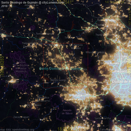
Analysis of Santo Domingo de Guzmán night lights 2016
Square area 10x10 km:
 0.83%
0.83%90-99
2.48%80-89
7.85%70-79
12.19%60-69
23.97%50-59
9.92%40-49
15.5%30-39
13.22%20-29
13.64%10-19
0.41%0-9
0%Square area 50x50 km:
0.23%90-99
0.59%80-89
2.41%70-79
4.12%60-69
8.06%50-59
4.67%40-49
7.32%30-39
6.12%20-29
8.95%10-19
18.91%0-9
38.63%Clear (daylight) street map image can be seen on geolist.org.
Map coordinates:
20° 15' 14.8" North, 100° 28' 58.3" West
19° 35' 35" North, 99° 46' 47" West
18° 55' 45.5" North, 99° 4' 35.8" West
Some cities around Santo Domingo de Guzmán sort by population:
• San Bartolo del Llano
4.1 km =2.5 mi,  93°
93°
• San Pedro de los Baños
10.2 km =6.3 mi,  325°
325°
• San Pedro Los Baños
5.7 km =3.5 mi,  309°
309°
• Jocotitlán
13 km =8.1 mi,  355°
355°
• Emiliano Zapata (Santo Domingo)
1.7 km =1.1 mi,  210°
210°
• La Concepción de los Baños
13.1 km =8.1 mi,  319°
319°
• Ixtlahuaca de Rayón
3 km =1.9 mi,  153°
153°
• San Bartolo Oxtotitlán
17.7 km =11 mi,  80°
80°
3516881 (p: 8,008)
Sources (retrieved 2019-11-25):
» Earth at Night: Flat Maps 2012, 2016