San Bartolo Oxtotitlán night lights from space
Night Light of San Bartolo Oxtotitlán (México) from space (Mexico) Src. Average luminocity for 10x10km area is 23.4979% and for 50x50km: 23.0079%.
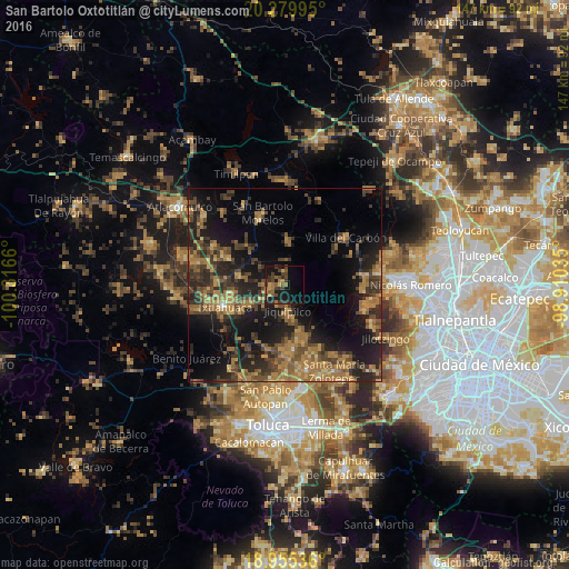
Analysis of San Bartolo Oxtotitlán night lights 2016
Square area 10x10 km:
 0%
0%90-99
0%80-89
1.65%70-79
3.31%60-69
5.79%50-59
4.75%40-49
8.88%30-39
8.68%20-29
4.13%10-19
26.45%0-9
36.36%Square area 50x50 km:
0.07%90-99
0.24%80-89
2.19%70-79
3.67%60-69
7.81%50-59
4.27%40-49
6.83%30-39
5.68%20-29
8.69%10-19
17.13%0-9
43.4%Clear (daylight) street map image can be seen on geolist.org.
Map coordinates:
20° 16' 47.8" North, 100° 18' 59.8" West
19° 37' 8.5" North, 99° 36' 48.5" West
18° 57' 19.3" North, 98° 54' 37.3" West
Some cities around San Bartolo Oxtotitlán sort by population:
• Villa del Carbón
19.9 km =12.4 mi,  52°
52°
• Santo Domingo de Guzmán
17.7 km =11 mi,  260°
260°
• Jocotitlán
20.9 km =13 mi,  298°
298°
• Emiliano Zapata (Santo Domingo)
18.8 km =11.7 mi, 256°
• San Pedro Arriba
15.7 km =9.8 mi,  160°
160°
• Ixtlahuaca de Rayón
17 km =10.6 mi,  250°
250°
• Quinto Barrio (Ejido Cahuacán)
20.5 km =12.7 mi,  89°
89°
• San Pedro Abajo
16.1 km =10 mi, 162°
3519634 (p: 5,155)
Sources (retrieved 2019-11-25):
» Earth at Night: Flat Maps 2012, 2016