San Bartolo del Llano night lights from space
Night Light of San Bartolo del Llano (México) from space (Mexico) Src. Average luminocity for 10x10km area is 50.4029% and for 50x50km: 25.615%.
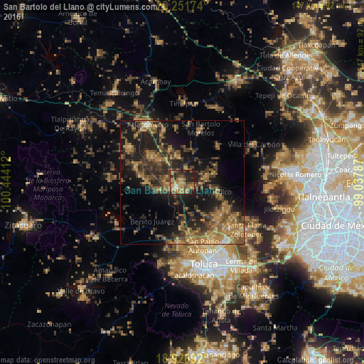
Analysis of San Bartolo del Llano night lights 2016
Square area 10x10 km:
 0.83%
0.83%90-99
2.48%80-89
6.82%70-79
11.36%60-69
22.11%50-59
10.33%40-49
9.5%30-39
8.26%20-29
18.8%10-19
9.5%0-9
0%Square area 50x50 km:
0.28%90-99
0.62%80-89
2.7%70-79
4.46%60-69
8.63%50-59
4.7%40-49
7.28%30-39
5.8%20-29
8.93%10-19
18.4%0-9
38.21%Clear (daylight) street map image can be seen on geolist.org.
Map coordinates:
20° 15' 6.3" North, 100° 26' 38.8" West
19° 35' 26.5" North, 99° 44' 27.6" West
18° 55' 36.9" North, 99° 2' 16.3" West
Some cities around San Bartolo del Llano sort by population:
• San Pedro de los Baños
13.1 km =8.1 mi,  311°
311°
• San Pedro Los Baños
9.3 km =5.8 mi,  294°
294°
• Santo Domingo de Guzmán
4.1 km =2.5 mi,  273°
273°
• Jocotitlán
14.2 km =8.8 mi,  339°
339°
• Emiliano Zapata (Santo Domingo)
5.1 km =3.2 mi,  256°
256°
• La Concepción de los Baños
16.2 km =10.1 mi, 309°
• Ixtlahuaca de Rayón
3.6 km =2.2 mi,  228°
228°
• San Pedro Abajo
21.9 km =13.6 mi,  123°
123°
3519642 (p: 12,227)
Sources (retrieved 2019-11-25):
» Earth at Night: Flat Maps 2012, 2016