La Concepción de los Baños night lights from space
Night Light of La Concepción de los Baños (México) from space (Mexico) Src. Average luminocity for 10x10km area is 41.2769% and for 50x50km: 20.6141%.
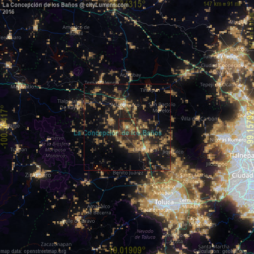
Analysis of La Concepción de los Baños night lights 2016
Square area 10x10 km:
 0%
0%90-99
0%80-89
3.51%70-79
6.82%60-69
12.4%50-59
8.88%40-49
12.19%30-39
23.35%20-29
19.63%10-19
13.22%0-9
0%Square area 50x50 km:
0.06%90-99
0.31%80-89
1.58%70-79
2.57%60-69
5.17%50-59
3.57%40-49
6.86%30-39
6.25%20-29
8.3%10-19
20.83%0-9
44.5%Clear (daylight) street map image can be seen on geolist.org.
Map coordinates:
20° 20' 35.3" North, 100° 33' 51" West
19° 40' 57" North, 99° 51' 39.7" West
19° 1' 8.7" North, 99° 9' 28.5" West
Some cities around La Concepción de los Baños sort by population:
• Atlacomulco de Fabela
13.1 km =8.1 mi,  353°
353°
• San Pedro de los Baños
3.1 km =1.9 mi,  119°
119°
• San Pedro Los Baños
7.6 km =4.7 mi,  147°
147°
• Santo Domingo de Guzmán
13.1 km =8.1 mi,  139°
139°
• Jocotitlán
8.2 km =5.1 mi,  68°
68°
• Santa María Citendejé
13.1 km =8.1 mi,  327°
327°
• San Miguel Tenochtitlán
10.8 km =6.7 mi,  323°
323°
• Santiago Citendejé
13.1 km =8.1 mi, 327°
3525956 (p: 7,207)
Sources (retrieved 2019-11-25):
» Earth at Night: Flat Maps 2012, 2016