Ixtlahuaca de Rayón night lights from space
Night Light of Ixtlahuaca de Rayón (México) from space (Mexico) Src. Average luminocity for 10x10km area is 49.686% and for 50x50km: 26.5068%.
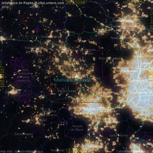
Analysis of Ixtlahuaca de Rayón night lights 2016
Square area 10x10 km:
 0.83%
0.83%90-99
2.48%80-89
8.06%70-79
10.95%60-69
21.9%50-59
7.85%40-49
11.78%30-39
6.4%20-29
12.19%10-19
17.56%0-9
0%Square area 50x50 km:
0.32%90-99
0.71%80-89
3.16%70-79
4.84%60-69
8.76%50-59
4.82%40-49
7.21%30-39
5.8%20-29
8.65%10-19
18.44%0-9
37.3%Clear (daylight) street map image can be seen on geolist.org.
Map coordinates:
20° 13' 48.1" North, 100° 28' 12.3" West
19° 34' 8" North, 99° 46' 1" West
18° 54' 18.1" North, 99° 3' 49.8" West
Some cities around Ixtlahuaca de Rayón sort by population:
• San Bartolo del Llano
3.6 km =2.2 mi,  48°
48°
• San Pedro de los Baños
13.2 km =8.2 mi,  327°
327°
• San Pedro Los Baños
8.5 km =5.3 mi,  317°
317°
• Santo Domingo de Guzmán
3 km =1.9 mi, 333°
• Jocotitlán
15.8 km =9.8 mi,  351°
351°
• Emiliano Zapata (Santo Domingo)
2.5 km =1.6 mi,  298°
298°
• La Concepción de los Baños
16 km =9.9 mi, 322°
• San Bartolo Oxtotitlán
17 km =10.6 mi,  70°
70°
3526670 (p: 6,934)
Sources (retrieved 2019-11-25):
» Earth at Night: Flat Maps 2012, 2016