San Pedro Los Baños night lights from space
Night Light of San Pedro Los Baños (México) from space (Mexico) Src. Average luminocity for 10x10km area is 41.9112% and for 50x50km: 22.6577%.
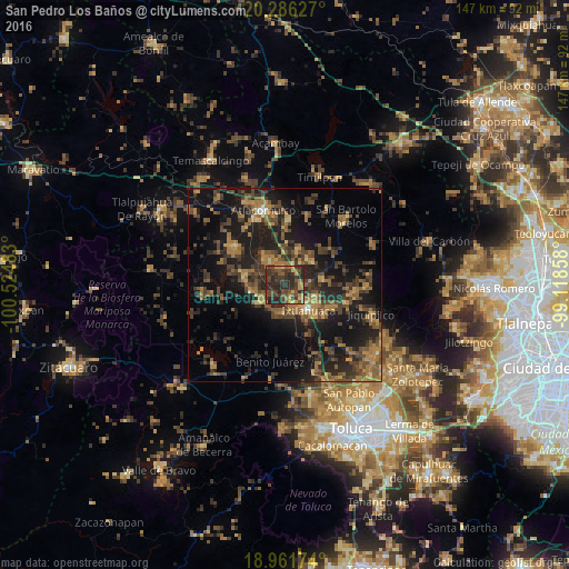
Analysis of San Pedro Los Baños night lights 2016
Square area 10x10 km:
 0%
0%90-99
0%80-89
3.93%70-79
7.23%60-69
8.68%50-59
8.26%40-49
16.12%30-39
25.21%20-29
29.75%10-19
0.83%0-9
0%Square area 50x50 km:
0.06%90-99
0.39%80-89
1.82%70-79
3.12%60-69
6.19%50-59
4.32%40-49
7.2%30-39
6.5%20-29
9.49%10-19
20.39%0-9
40.54%Clear (daylight) street map image can be seen on geolist.org.
Map coordinates:
20° 17' 10.6" North, 100° 31' 29.4" West
19° 37' 31.3" North, 99° 49' 18.1" West
18° 57' 42.3" North, 99° 7' 6.9" West
Some cities around San Pedro Los Baños sort by population:
• San Bartolo del Llano
9.3 km =5.8 mi,  114°
114°
• Santo Domingo de Guzmán
5.7 km =3.5 mi,  129°
129°
• Jocotitlán
10 km =6.2 mi,  20°
20°
• Emiliano Zapata (Santo Domingo)
6.2 km =3.9 mi,  145°
145°
• La Concepción de los Baños
7.6 km =4.7 mi,  327°
327°
• Ixtlahuaca de Rayón
8.5 km =5.3 mi,  137°
137°
• Santiago Acutzilapan
18.8 km =11.7 mi, 18°
• San Miguel Tenochtitlán
18.3 km =11.4 mi,  324°
324°
3517984 (p: 11,886)
Sources (retrieved 2019-11-25):
» Earth at Night: Flat Maps 2012, 2016