Santiago Acatlán night lights from space
Night Light of Santiago Acatlán (Puebla) from space (Mexico) Src. Average luminocity for 10x10km area is 48.2316% and for 50x50km: 29.9534%.
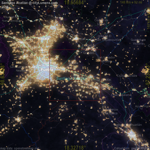
Analysis of Santiago Acatlán night lights 2016
Square area 10x10 km:
 1.08%
1.08%90-99
1.52%80-89
14.5%70-79
10.61%60-69
8.44%50-59
5.19%40-49
9.74%30-39
15.58%20-29
27.92%10-19
5.41%0-9
0%Square area 50x50 km:
1.79%90-99
2.52%80-89
6.87%70-79
4.5%60-69
4.71%50-59
3.1%40-49
7.11%30-39
7.47%20-29
10.25%10-19
16.63%0-9
35.06%Clear (daylight) street map image can be seen on geolist.org.
Map coordinates:
19° 39' 24.6" North, 98° 38' 12.8" West
18° 59' 36" North, 97° 56' 1.5" West
18° 19' 37.8" North, 97° 13' 50.3" West
Some cities around Santiago Acatlán sort by population:
• Amozoc de Mota
13.1 km =8.1 mi,  296°
296°
• Tepeaca
4.6 km =2.9 mi,  129°
129°
• Acajete
13.3 km =8.3 mi,  351°
351°
• Tepatlaxco de Hidalgo
10.6 km =6.6 mi,  336°
336°
• San Hipólito
8.6 km =5.3 mi, 132°
• La Magdalena Tetela Morelos
6.3 km =3.9 mi, 352°
• San Agustín Tlaxco
9.3 km =5.8 mi,  319°
319°
• Tecali
11 km =6.8 mi,  200°
200°
3516975 (p: 7,601)
Sources (retrieved 2019-11-25):
» Earth at Night: Flat Maps 2012, 2016