La Magdalena Tetela Morelos night lights from space
Night Light of La Magdalena Tetela Morelos (Puebla) from space (Mexico) Src. Average luminocity for 10x10km area is 45.9026% and for 50x50km: 31.8381%.
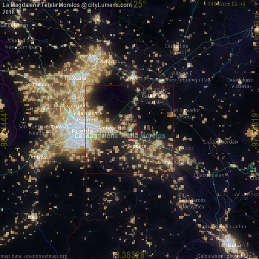
Analysis of La Magdalena Tetela Morelos night lights 2016
Square area 10x10 km:
 0%
0%90-99
1.95%80-89
8.66%70-79
12.99%60-69
9.31%50-59
5.63%40-49
11.04%30-39
14.29%20-29
25.32%10-19
10.82%0-9
0%Square area 50x50 km:
2.25%90-99
2.98%80-89
7.25%70-79
4.75%60-69
4.96%50-59
3.5%40-49
7.5%30-39
7.07%20-29
10.16%10-19
17.68%0-9
31.92%Clear (daylight) street map image can be seen on geolist.org.
Map coordinates:
19° 42' 45" North, 98° 38' 40" West
19° 2' 57.2" North, 97° 56' 28.7" West
18° 22' 59.8" North, 97° 14' 17.5" West
Some cities around La Magdalena Tetela Morelos sort by population:
• Amozoc de Mota
10.9 km =6.8 mi,  268°
268°
• Tepeaca
10.1 km =6.3 mi,  154°
154°
• Acajete
7 km =4.3 mi,  350°
350°
• Tepatlaxco de Hidalgo
4.9 km =3 mi,  316°
316°
• San Juan Tepulco
9 km =5.6 mi,  326°
326°
• Santiago Acatlán
6.3 km =3.9 mi,  172°
172°
• San Agustín Tlaxco
5.3 km =3.3 mi,  278°
278°
• El Rincón Citlaltépetl
12.8 km =8 mi,  22°
22°
3523752 (p: 6,421)
Sources (retrieved 2019-11-25):
» Earth at Night: Flat Maps 2012, 2016