San Hipólito night lights from space
Night Light of San Hipólito (Puebla) from space (Mexico) Src. Average luminocity for 10x10km area is 56.4827% and for 50x50km: 25.7071%.
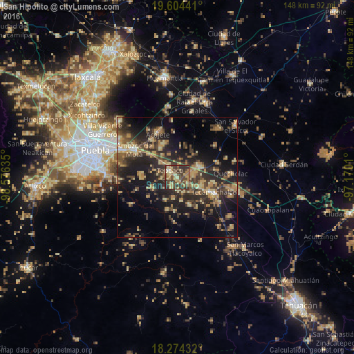
Analysis of San Hipólito night lights 2016
Square area 10x10 km:
 1.08%
1.08%90-99
2.81%80-89
18.18%70-79
8.87%60-69
12.77%50-59
4.11%40-49
28.14%30-39
16.67%20-29
7.14%10-19
0.22%0-9
0%Square area 50x50 km:
0.49%90-99
1.16%80-89
5.61%70-79
4.19%60-69
4.66%50-59
2.89%40-49
6.48%30-39
7.21%20-29
10.16%10-19
17.36%0-9
39.78%Clear (daylight) street map image can be seen on geolist.org.
Map coordinates:
19° 36' 15.9" North, 98° 34' 34.9" West
18° 56' 26.5" North, 97° 52' 23.6" West
18° 16' 27.6" North, 97° 10' 12.4" West
Some cities around San Hipólito sort by population:
• Tepeaca
4 km =2.5 mi,  316°
316°
• Acatzingo
10.5 km =6.5 mi,  64°
64°
• Los Reyes de Juárez
7.4 km =4.6 mi,  82°
82°
• Santiago Acatlán
8.6 km =5.3 mi,  312°
312°
• Actipan de Morelos
8.1 km =5 mi,  74°
74°
• Cuapiaxtla de Madero
5.9 km =3.7 mi,  118°
118°
• Hueyotlipan
5.5 km =3.4 mi,  171°
171°
• San Martín Caltenco
8.4 km =5.2 mi,  137°
137°
3519207 (p: 8,999)
Sources (retrieved 2019-11-25):
» Earth at Night: Flat Maps 2012, 2016