San Agustín Tlaxco night lights from space
Night Light of San Agustín Tlaxco (Puebla) from space (Mexico) Src. Average luminocity for 10x10km area is 47.6797% and for 50x50km: 37.0271%.
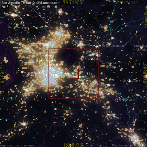
Analysis of San Agustín Tlaxco night lights 2016
Square area 10x10 km:
 0.65%
0.65%90-99
1.95%80-89
9.09%70-79
12.12%60-69
8.01%50-59
7.58%40-49
16.23%30-39
13.64%20-29
27.06%10-19
3.68%0-9
0%Square area 50x50 km:
5.11%90-99
4.3%80-89
8.35%70-79
5.89%60-69
4.67%50-59
3.71%40-49
7.26%30-39
6.97%20-29
9.2%10-19
17.12%0-9
27.43%Clear (daylight) street map image can be seen on geolist.org.
Map coordinates:
19° 43' 10.4" North, 98° 41' 41" West
19° 3' 22.7" North, 97° 59' 29.7" West
18° 23' 25.4" North, 97° 17' 18.5" West
Some cities around San Agustín Tlaxco sort by population:
• Amozoc de Mota
5.7 km =3.5 mi,  258°
258°
• Acajete
7.4 km =4.6 mi,  33°
33°
• Casa Blanca
13.5 km =8.4 mi, 263°
• Tepatlaxco de Hidalgo
3.3 km =2.1 mi,  35°
35°
• Santa María Xonacatepec
12.3 km =7.6 mi,  287°
287°
• San Juan Tepulco
6.8 km =4.2 mi,  2°
2°
• Santiago Acatlán
9.3 km =5.8 mi,  139°
139°
• La Magdalena Tetela Morelos
5.3 km =3.3 mi,  98°
98°
11087403 (p: 6,163)
Sources (retrieved 2019-11-25):
» Earth at Night: Flat Maps 2012, 2016