Tlaltizapán night lights from space
Night Light of Tlaltizapán (Morelos) from space (Mexico) Src. Average luminocity for 10x10km area is 27.1901% and for 50x50km: 27.9714%.
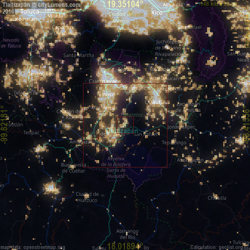
Analysis of Tlaltizapán night lights 2016
Square area 10x10 km:
 0%
0%90-99
0.21%80-89
4.34%70-79
7.85%60-69
4.96%50-59
3.1%40-49
6.2%30-39
6.2%20-29
13.02%10-19
21.07%0-9
33.06%Square area 50x50 km:
1.31%90-99
2.68%80-89
6.22%70-79
5.81%60-69
5.71%50-59
3.61%40-49
6.12%30-39
4.99%20-29
7.26%10-19
13.15%0-9
43.15%Clear (daylight) street map image can be seen on geolist.org.
Map coordinates:
19° 21' 3.7" North, 99° 49' 18.5" West
18° 41' 10.7" North, 99° 7' 7.2" West
18° 1' 8.2" North, 98° 24' 56" West
Some cities around Tlaltizapán sort by population:
• Zacatepec
8.3 km =5.2 mi,  244°
244°
• Xoxocotla
13.4 km =8.3 mi,  268°
268°
• Jojutla
10.3 km =6.4 mi,  219°
219°
• Tlaquiltenango
7.4 km =4.6 mi, 219°
• Santa Rosa Treinta
7 km =4.3 mi,  282°
282°
• Galeana
11.2 km =7 mi, 241°
• Tlatenchi
12.3 km =7.6 mi, 215°
• Pedro Amaro
11.5 km =7.1 mi,  209°
209°
3515415 (p: 10,563)
Sources (retrieved 2019-11-25):
» Earth at Night: Flat Maps 2012, 2016