Santa María Jajalpa night lights from space
Night Light of Santa María Jajalpa (México) from space (Mexico) Src. Average luminocity for 10x10km area is 26.8918% and for 50x50km: 38.0429%.
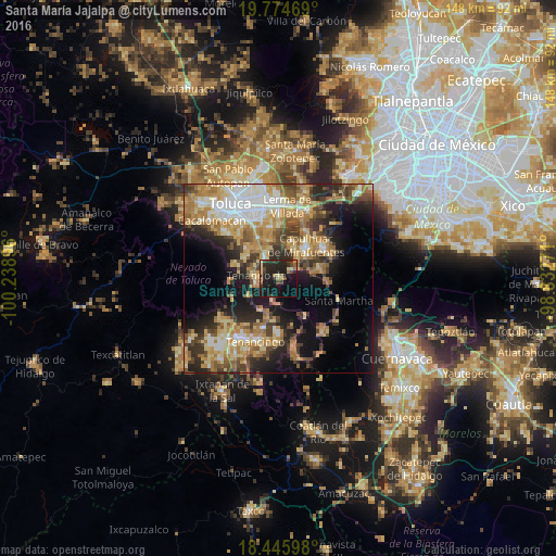
Analysis of Santa María Jajalpa night lights 2016
Square area 10x10 km:
 0.65%
0.65%90-99
0.22%80-89
5.19%70-79
2.16%60-69
4.76%50-59
2.38%40-49
6.28%30-39
4.33%20-29
21.86%10-19
37.23%0-9
14.94%Square area 50x50 km:
4.83%90-99
5.01%80-89
7.53%70-79
7.04%60-69
7.94%50-59
4.34%40-49
5.77%30-39
5.17%20-29
8.49%10-19
13.67%0-9
30.19%Clear (daylight) street map image can be seen on geolist.org.
Map coordinates:
19° 46' 28.9" North, 100° 14' 20.3" West
19° 6' 42" North, 99° 32' 9" West
18° 26' 45.5" North, 98° 49' 57.8" West
Some cities around Santa María Jajalpa sort by population:
• Tenango de Arista
5.7 km =3.5 mi,  261°
261°
• San Antonio la Isla
6.7 km =4.2 mi,  330°
330°
• Calimaya
10.4 km =6.5 mi,  303°
303°
• Almoloya del Río
7.4 km =4.6 mi,  43°
43°
• Ex-Rancho San Dimas
7.6 km =4.7 mi,  335°
335°
• San Bartolomé Atlatlahuca
9.1 km =5.7 mi,  238°
238°
• Chapultepec
10.4 km =6.5 mi, 344°
• San Pedro Zictepec
9.4 km =5.8 mi,  207°
207°
3827304 (p: 6,755)
Sources (retrieved 2019-11-25):
» Earth at Night: Flat Maps 2012, 2016