San Antonio la Isla night lights from space
Night Light of San Antonio la Isla (México) from space (Mexico) Src. Average luminocity for 10x10km area is 52.3745% and for 50x50km: 42.3075%.
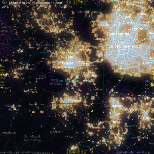
Analysis of San Antonio la Isla night lights 2016
Square area 10x10 km:
 0.87%
0.87%90-99
2.6%80-89
14.07%70-79
10.82%60-69
14.07%50-59
8.44%40-49
11.69%30-39
11.26%20-29
23.38%10-19
2.81%0-9
0%Square area 50x50 km:
5.27%90-99
5.58%80-89
8.66%70-79
8.6%60-69
9.34%50-59
4.77%40-49
6.08%30-39
5.57%20-29
8.76%10-19
12.42%0-9
24.95%Clear (daylight) street map image can be seen on geolist.org.
Map coordinates:
19° 49' 38" North, 100° 16' 11.9" West
19° 9' 51.9" North, 99° 34' 0.7" West
18° 29' 56.1" North, 98° 51' 49.4" West
Some cities around San Antonio la Isla sort by population:
• Tenango de Arista
7.1 km =4.4 mi,  199°
199°
• Calimaya
5.4 km =3.4 mi,  268°
268°
• Mexicaltzingo
5.5 km =3.4 mi,  340°
340°
• Santa María Rayón
2.3 km =1.4 mi,  216°
216°
• Ex-Rancho San Dimas
1.1 km =0.7 mi,  8°
8°
• San Miguel Totocuitlapilco
7.7 km =4.8 mi, 338°
• Santa María Jajalpa
6.7 km =4.2 mi,  150°
150°
• Chapultepec
4.2 km =2.6 mi, 7°
3519833 (p: 12,525)
Sources (retrieved 2019-11-25):
» Earth at Night: Flat Maps 2012, 2016