San Jerónimo Amanalco night lights from space
Night Light of San Jerónimo Amanalco (México) from space (Mexico) Src. Average luminocity for 10x10km area is 49.2562% and for 50x50km: 42.5757%.
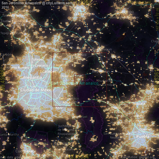
Analysis of San Jerónimo Amanalco night lights 2016
Square area 10x10 km:
 0.83%
0.83%90-99
4.13%80-89
12.4%70-79
7.44%60-69
10.95%50-59
18.39%40-49
7.85%30-39
10.95%20-29
7.85%10-19
13.84%0-9
5.37%Square area 50x50 km:
7.72%90-99
7.1%80-89
9.11%70-79
8.76%60-69
7.36%50-59
4.57%40-49
4.26%30-39
3.08%20-29
4.51%10-19
11.18%0-9
32.33%Clear (daylight) street map image can be seen on geolist.org.
Map coordinates:
20° 10' 45.3" North, 99° 27' 35.5" West
19° 31' 4.5" North, 98° 45' 24.2" West
18° 51' 13.8" North, 98° 3' 13" West
Some cities around San Jerónimo Amanalco sort by population:
• Tulantongo
12.4 km =7.7 mi,  277°
277°
• San Miguel Tlaixpan
5.7 km =3.5 mi,  260°
260°
• Tepetlaoxtoc de Hidalgo
9 km =5.6 mi,  314°
314°
• Concepción Jolalpan
11.9 km =7.4 mi, 308°
• Santa Catarina del Monte
4.1 km =2.5 mi,  203°
203°
• Tequexquináhuac
8.4 km =5.2 mi,  237°
237°
• Xochimanca
7.7 km =4.8 mi,  246°
246°
• Xocotlán
9.4 km =5.8 mi,  268°
268°
3817705 (p: 6,519)
Sources (retrieved 2019-11-25):
» Earth at Night: Flat Maps 2012, 2016