Santa Bárbara night lights from space
Night Light of Santa Bárbara (Chihuahua) from space (Mexico) Src. Average luminocity for 10x10km area is 8.0595% and for 50x50km: 3.0702%.
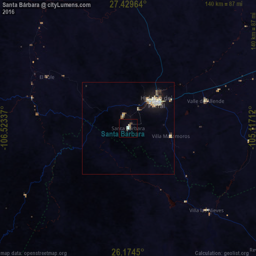
Analysis of Santa Bárbara night lights 2016
Square area 10x10 km:
 0.6%
0.6%90-99
2.18%80-89
1.19%70-79
0%60-69
0%50-59
1.98%40-49
1.19%30-39
1.59%20-29
0%10-19
0%0-9
91.27%Square area 50x50 km:
0.21%90-99
0.63%80-89
0.63%70-79
0.3%60-69
0.25%50-59
0.3%40-49
0.28%30-39
0.37%20-29
0.51%10-19
2.53%0-9
93.99%Clear (daylight) street map image can be seen on geolist.org.
Map coordinates:
27° 25' 46.7" North, 106° 31' 24.1" West
26° 48' 13.7" North, 105° 49' 12.9" West
26° 10' 28.2" North, 105° 7' 1.6" West
Some cities around Santa Bárbara sort by population:
• Ciudad Delicias
158 km =98.2 mi,  12°
12°
• Parral
20.7 km =12.9 mi,  47°
47°
• Camargo
116.5 km =72.4 mi,  33°
33°
• José Mariano Jiménez
96 km =59.7 mi,  67°
67°
• Guachochi
124.5 km =77.4 mi,  270°
270°
• Saucillo
146 km =90.7 mi,  20°
20°
• Guadalupe y Calvo
138.6 km =86.1 mi,  235°
235°
• Rosales
156 km =96.9 mi, 9°
3984629 (p: 8,765)
Sources (retrieved 2019-11-25):
» Earth at Night: Flat Maps 2012, 2016