Rosales night lights from space
Night Light of Rosales (Chihuahua) from space (Mexico) Src. Average luminocity for 10x10km area is 18.627% and for 50x50km: 7.3054%.
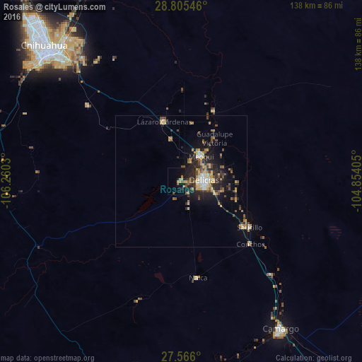
Analysis of Rosales night lights 2016
Square area 10x10 km:
 0%
0%90-99
0%80-89
3.37%70-79
2.58%60-69
1.79%50-59
4.17%40-49
3.97%30-39
2.78%20-29
12.3%10-19
22.42%0-9
46.63%Square area 50x50 km:
0.39%90-99
0.57%80-89
1.49%70-79
1.33%60-69
0.68%50-59
1.05%40-49
1.31%30-39
1.25%20-29
2.57%10-19
4.75%0-9
84.61%Clear (daylight) street map image can be seen on geolist.org.
Map coordinates:
28° 48' 19.7" North, 106° 15' 37.1" West
28° 11' 15.1" North, 105° 33' 25.8" West
27° 33' 57.6" North, 104° 51' 14.6" West
Some cities around Rosales sort by population:
• Ciudad Delicias
8.5 km =5.3 mi,  88°
88°
• Camargo
68.1 km =42.3 mi,  146°
146°
• Jiménez
22.4 km =13.9 mi,  43°
43°
• Meoqui
12.1 km =7.5 mi, 38°
• Saucillo
31.2 km =19.4 mi,  124°
124°
• Lázaro Cárdenas
23.5 km =14.6 mi,  343°
343°
• Ampliación Colonia Lázaro Cárdenas
22.5 km =14 mi,  345°
345°
• Santa Eulalia
55.6 km =34.5 mi,  324°
324°
3988430 (p: 5,570)
Sources (retrieved 2019-11-25):
» Earth at Night: Flat Maps 2012, 2016