Cerro Gordo night lights from space
Night Light of Cerro Gordo (Guanajuato) from space (Mexico) Src. Average luminocity for 10x10km area is 59.358% and for 50x50km: 32.0939%.
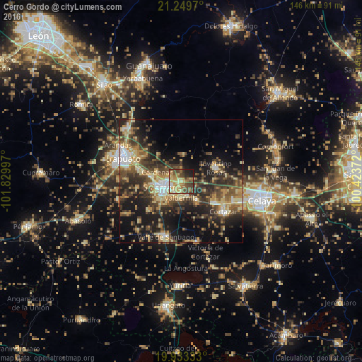
Analysis of Cerro Gordo night lights 2016
Square area 10x10 km:
 3.6%
3.6%90-99
6.06%80-89
19.32%70-79
10.23%60-69
9.85%50-59
9.66%40-49
19.32%30-39
8.71%20-29
6.25%10-19
7.01%0-9
0%Square area 50x50 km:
2.6%90-99
3.01%80-89
6.07%70-79
5.36%60-69
4.45%50-59
4.75%40-49
8.15%30-39
8.07%20-29
9.75%10-19
16.88%0-9
30.91%Clear (daylight) street map image can be seen on geolist.org.
Map coordinates:
21° 14' 58.9" North, 101° 49' 47.9" West
20° 35' 34.6" North, 101° 7' 36.6" West
19° 55' 60" North, 100° 25' 25.4" West
Some cities around Cerro Gordo sort by population:
• Salamanca
7.1 km =4.4 mi,  250°
250°
• Juventino Rosas
15 km =9.3 mi,  68°
68°
• Villagrán
16 km =9.9 mi,  122°
122°
• Valtierrilla
6.7 km =4.2 mi,  180°
180°
• Santiago de Cuenda
13.8 km =8.6 mi,  86°
86°
• San José Temascatío
17.7 km =11 mi,  308°
308°
• Mexicanos
9.2 km =5.7 mi,  140°
140°
• Sarabia
10.4 km =6.5 mi, 139°
4014740 (p: 5,460)
Sources (retrieved 2019-11-25):
» Earth at Night: Flat Maps 2012, 2016