Villas de Irapuato night lights from space
Night Light of Villas de Irapuato (Guanajuato) from space (Mexico) Src. Average luminocity for 10x10km area is 63.0455% and for 50x50km: 27.9551%.
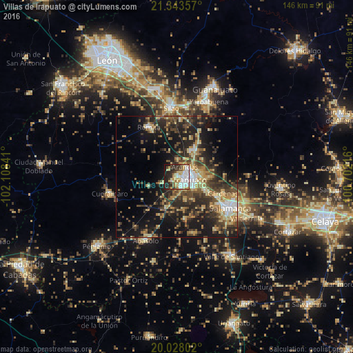
Analysis of Villas de Irapuato night lights 2016
Square area 10x10 km:
 16.86%
90-99
12.88%80-89
15.72%70-79
6.63%60-69
3.03%50-59
4.36%40-49
6.63%30-39
8.52%20-29
14.96%10-19
9.85%0-9
0.57%Square area 50x50 km:
2.45%90-99
2.74%80-89
4.77%70-79
4.39%60-69
3.63%50-59
3.74%40-49
7.06%30-39
6.48%20-29
9.83%10-19
17.07%0-9
37.84%Clear (daylight) street map image can be seen on geolist.org.
Map coordinates:
21° 20' 36.9" North, 102° 6' 30.3" West
20° 41' 14" North, 101° 24' 19" West
20° 1' 40.9" North, 100° 42' 7.8" West
Some cities around Villas de Irapuato sort by population:
• Irapuato
5.2 km =3.2 mi,  102°
102°
• Salamanca
25.7 km =16 mi,  119°
119°
• Romita
23.5 km =14.6 mi,  330°
330°
• Cuerámaro
28.6 km =17.8 mi,  256°
256°
• Arandas
5.4 km =3.4 mi,  38°
38°
• San José Temascatío
15.1 km =9.4 mi,  88°
88°
• La Aldea
25 km =15.5 mi,  342°
342°
• San Roque
11.8 km =7.3 mi,  145°
145°
8858258 (p: 5,199)
Sources (retrieved 2019-11-25):
» Earth at Night: Flat Maps 2012, 2016