San Pablo Tecalco night lights from space
Night Light of San Pablo Tecalco (México) from space (Mexico) Src. Average luminocity for 10x10km area is 82.6694% and for 50x50km: 68.663%.
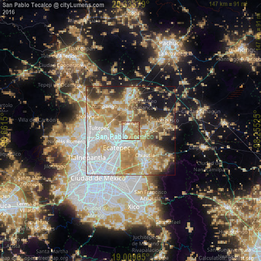
Analysis of San Pablo Tecalco night lights 2016
Square area 10x10 km:
 16.32%
90-99
18.39%80-89
21.07%70-79
26.45%60-69
13.43%50-59
4.34%40-49
0%30-39
0%20-29
0%10-19
0%0-9
0%Square area 50x50 km:
19.62%90-99
11.4%80-89
13.64%70-79
13.2%60-69
10.52%50-59
6.29%40-49
5.29%30-39
4.08%20-29
5.81%10-19
7.7%0-9
2.46%Clear (daylight) street map image can be seen on geolist.org.
Map coordinates:
20° 20' 1.6" North, 99° 39' 41.4" West
19° 40' 23.1" North, 98° 57' 30.1" West
19° 0' 34.7" North, 98° 15' 18.9" West
Some cities around San Pablo Tecalco sort by population:
• Ojo de Agua
5.5 km =3.4 mi,  278°
278°
• San Martín Azcatepec
2.1 km =1.3 mi,  315°
315°
• Tecámac de Felipe Villanueva
4.6 km =2.9 mi,  346°
346°
• Tecámac
4.6 km =2.9 mi, 345°
• Santo Tomás Chiconautla
6.4 km =4 mi,  233°
233°
• Acolman de Netzahualcóyotl
6.5 km =4 mi,  124°
124°
• Santa Catarina
5.3 km =3.3 mi,  140°
140°
• San Bartolo
6.2 km =3.9 mi,  108°
108°
3518122 (p: 5,344)
Sources (retrieved 2019-11-25):
» Earth at Night: Flat Maps 2012, 2016