Santo Tomás Chiconautla night lights from space
Night Light of Santo Tomás Chiconautla (México) from space (Mexico) Src. Average luminocity for 10x10km area is 96.7128% and for 50x50km: 77.3286%.
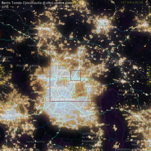
Analysis of Santo Tomás Chiconautla night lights 2016
Square area 10x10 km:
 59.71%
90-99
25.21%80-89
10.33%70-79
4.75%60-69
0%50-59
0%40-49
0%30-39
0%20-29
0%10-19
0%0-9
0%Square area 50x50 km:
28.57%90-99
14.46%80-89
13.26%70-79
12.59%60-69
10.23%50-59
6.29%40-49
4.12%30-39
2.58%20-29
3.13%10-19
3.38%0-9
1.39%Clear (daylight) street map image can be seen on geolist.org.
Map coordinates:
20° 17' 59.2" North, 99° 42' 38.4" West
19° 38' 20.2" North, 99° 0' 27.2" West
18° 58' 31.3" North, 98° 18' 15.9" West
Some cities around Santo Tomás Chiconautla sort by population:
• Ecatepec de Morelos
6.7 km =4.2 mi,  235°
235°
• Ojo de Agua
4.6 km =2.9 mi,  356°
356°
• San Martín Azcatepec
6.4 km =4 mi,  34°
34°
• Alborada Jaltenco
6.9 km =4.3 mi,  291°
291°
• Tequisistlán Primero
6.8 km =4.2 mi,  129°
129°
• Tonanitla
7.3 km =4.5 mi,  318°
318°
• Granjas Ampliación Santa Rosa
6.7 km =4.2 mi,  140°
140°
• San Pablo Tecalco
6.4 km =4 mi,  53°
53°
3827600 (p: 7,844)
Sources (retrieved 2019-11-25):
» Earth at Night: Flat Maps 2012, 2016