Acolman de Netzahualcóyotl night lights from space
Night Light of Acolman de Netzahualcóyotl (México) from space (Mexico) Src. Average luminocity for 10x10km area is 78.874% and for 50x50km: 63.0773%.
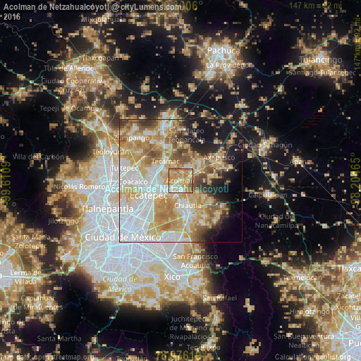
Analysis of Acolman de Netzahualcóyotl night lights 2016
Square area 10x10 km:
 7.23%
7.23%90-99
17.56%80-89
18.18%70-79
34.09%60-69
16.94%50-59
5.99%40-49
0%30-39
0%20-29
0%10-19
0%0-9
0%Square area 50x50 km:
17.41%90-99
10.34%80-89
12.74%70-79
12.26%60-69
9.74%50-59
6.21%40-49
4.75%30-39
3.35%20-29
4.68%10-19
9.86%0-9
8.68%Clear (daylight) street map image can be seen on geolist.org.
Map coordinates:
20° 18' 2.2" North, 99° 36' 39.2" West
19° 38' 23.1" North, 98° 54' 28" West
18° 58' 34.3" North, 98° 12' 16.7" West
Some cities around Acolman de Netzahualcóyotl sort by population:
• Tepexpan
4.2 km =2.6 mi,  226°
226°
• Tezoyuca
5.2 km =3.2 mi,  183°
183°
• Tequisistlán Primero
6.8 km =4.2 mi, 229°
• Tequisistlán
5.9 km =3.7 mi,  215°
215°
• San Lorenzo Tlalmimilolpan
4.8 km =3 mi,  50°
50°
• San Pablo Tecalco
6.5 km =4 mi,  304°
304°
• Santa Catarina
2 km =1.2 mi,  259°
259°
• San Bartolo
1.8 km =1.1 mi,  18°
18°
3533404 (p: 5,571)
Sources (retrieved 2019-11-25):
» Earth at Night: Flat Maps 2012, 2016