San Bartolo night lights from space
Night Light of San Bartolo (México) from space (Mexico) Src. Average luminocity for 10x10km area is 77.3285% and for 50x50km: 61.1101%.
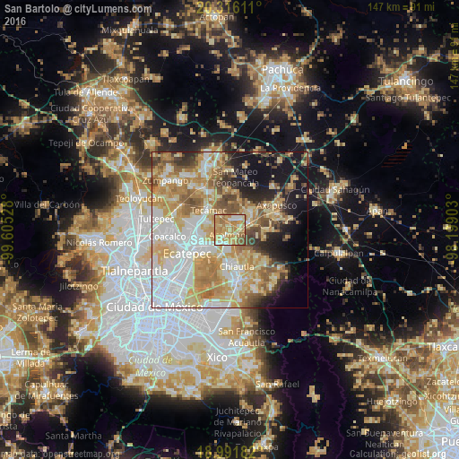
Analysis of San Bartolo night lights 2016
Square area 10x10 km:
 6.82%
6.82%90-99
13.84%80-89
21.9%70-79
27.27%60-69
21.28%50-59
8.88%40-49
0%30-39
0%20-29
0%10-19
0%0-9
0%Square area 50x50 km:
15.12%90-99
9.8%80-89
12.83%70-79
12.41%60-69
10.06%50-59
6.21%40-49
5%30-39
3.48%20-29
5.24%10-19
10.82%0-9
9.02%Clear (daylight) street map image can be seen on geolist.org.
Map coordinates:
20° 18' 58" North, 99° 36' 19" West
19° 39' 19.2" North, 98° 54' 7.7" West
18° 59' 30.6" North, 98° 11' 56.5" West
Some cities around San Bartolo sort by population:
• Tepexpan
5.8 km =3.6 mi,  217°
217°
• Teotihuacán de Arista
5.8 km =3.6 mi,  48°
48°
• Teotihuacán
5.7 km =3.5 mi, 49°
• Acolman de Netzahualcóyotl
1.8 km =1.1 mi,  198°
198°
• San Lorenzo Tlalmimilolpan
3.4 km =2.1 mi,  66°
66°
• San Sebastián Xolalpa
6.4 km =4 mi, 68°
• San Pablo Tecalco
6.2 km =3.9 mi,  288°
288°
• Santa Catarina
3.3 km =2.1 mi,  230°
230°
3817755 (p: 5,099)
Sources (retrieved 2019-11-25):
» Earth at Night: Flat Maps 2012, 2016