Almecatla night lights from space
Night Light of Almecatla (Puebla) from space (Mexico) Src. Average luminocity for 10x10km area is 88.1537% and for 50x50km: 58.0571%.
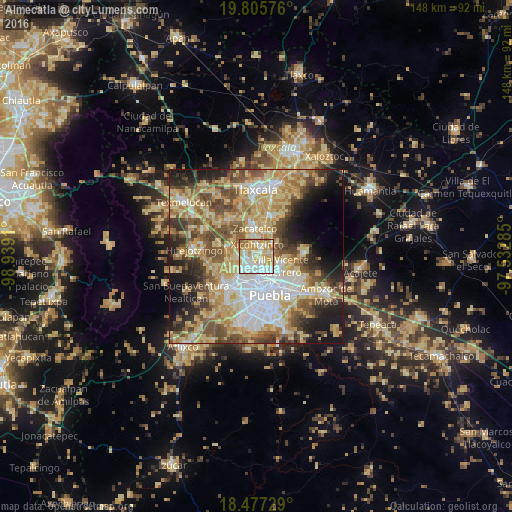
Analysis of Almecatla night lights 2016
Square area 10x10 km:
 22.51%
90-99
27.49%80-89
25.54%70-79
15.37%60-69
7.79%50-59
1.3%40-49
0%30-39
0%20-29
0%10-19
0%0-9
0%Square area 50x50 km:
10.32%90-99
8.45%80-89
15.43%70-79
10.12%60-69
7.97%50-59
8.47%40-49
8.95%30-39
5.72%20-29
6.77%10-19
9.13%0-9
8.66%Clear (daylight) street map image can be seen on geolist.org.
Map coordinates:
19° 48' 20.7" North, 98° 56' 20.8" West
19° 8' 34.3" North, 98° 14' 9.5" West
18° 28' 38.2" North, 97° 31' 58.3" West
Some cities around Almecatla sort by population:
• Sanctorum
5.2 km =3.2 mi,  201°
201°
• Cuautlancingo
7.1 km =4.4 mi,  213°
213°
• Papalotla
4.4 km =2.7 mi,  49°
49°
• Xicohtzinco
3.4 km =2.1 mi,  3°
3°
• San Francisco Ocotlán
5.1 km =3.2 mi,  258°
258°
• Tenancingo
3.7 km =2.3 mi,  82°
82°
• Mazatecochco
6.5 km =4 mi, 52°
• Santa Catarina Ayometla
6.6 km =4.1 mi,  20°
20°
3518543 (p: 13,217)
Sources (retrieved 2019-11-25):
» Earth at Night: Flat Maps 2012, 2016