San Antonio Mihuacán night lights from space
Night Light of San Antonio Mihuacán (Puebla) from space (Mexico) Src. Average luminocity for 10x10km area is 72.7078% and for 50x50km: 58.5649%.
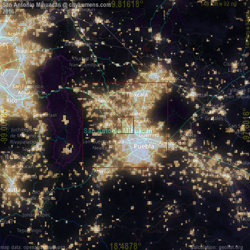
Analysis of San Antonio Mihuacán night lights 2016
Square area 10x10 km:
 5.63%
5.63%90-99
7.58%80-89
26.19%70-79
16.88%60-69
14.5%50-59
24.68%40-49
3.46%30-39
1.08%20-29
0%10-19
0%0-9
0%Square area 50x50 km:
10.16%90-99
8.3%80-89
15.67%70-79
10.81%60-69
8.29%50-59
8.62%40-49
8.69%30-39
5.35%20-29
6.94%10-19
8.5%0-9
8.68%Clear (daylight) street map image can be seen on geolist.org.
Map coordinates:
19° 48' 58.2" North, 99° 0' 28.3" West
19° 9' 12" North, 98° 18' 17" West
18° 29' 16.1" North, 97° 36' 5.8" West
Some cities around San Antonio Mihuacán sort by population:
• Coronango
3.6 km =2.2 mi,  182°
182°
• Almecatla
7.3 km =4.5 mi,  99°
99°
• Santa María Zacatepec
7.2 km =4.5 mi,  242°
242°
• Xicohtzinco
7.8 km =4.8 mi,  73°
73°
• San Francisco Ocotlán
3.1 km =1.9 mi,  133°
133°
• San Miguel Xoxtla
1.6 km =1 mi,  349°
349°
• Tlaltenango
4.3 km =2.7 mi,  298°
298°
• Cuanalá
5.5 km =3.4 mi,  206°
206°
8858205 (p: 6,826)
Sources (retrieved 2019-11-25):
» Earth at Night: Flat Maps 2012, 2016