Casa Blanca night lights from space
Night Light of Casa Blanca (Puebla) from space (Mexico) Src. Average luminocity for 10x10km area is 82.8355% and for 50x50km: 46.2941%.
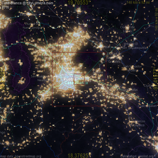
Analysis of Casa Blanca night lights 2016
Square area 10x10 km:
 24.89%
90-99
22.73%80-89
16.67%70-79
11.26%60-69
6.28%50-59
12.77%40-49
3.9%30-39
1.3%20-29
0.22%10-19
0%0-9
0%Square area 50x50 km:
9.35%90-99
6.87%80-89
10.55%70-79
7.63%60-69
5.42%50-59
5.55%40-49
6.57%30-39
5.03%20-29
7.55%10-19
13.17%0-9
22.32%Clear (daylight) street map image can be seen on geolist.org.
Map coordinates:
19° 42' 19.9" North, 98° 49' 19.3" West
19° 2' 32" North, 98° 7' 8" West
18° 22' 34.5" North, 97° 24' 56.8" West
Some cities around Casa Blanca sort by population:
• Puebla
8.9 km =5.5 mi,  266°
266°
• Amozoc de Mota
7.8 km =4.8 mi,  86°
86°
• Villa Vicente Guerrero
10.1 km =6.3 mi,  330°
330°
• San Miguel Canoa
12.3 km =7.6 mi,  7°
7°
• Santa María Xonacatepec
5.5 km =3.4 mi,  17°
17°
• La Resurrección
6.8 km =4.2 mi,  350°
350°
• San Sebastián de Aparicio
8.1 km =5 mi, 327°
• Santo Tomás Chautla
9.2 km =5.7 mi,  202°
202°
8858116 (p: 17,262)
Sources (retrieved 2019-11-25):
» Earth at Night: Flat Maps 2012, 2016