San Juan Tepulco night lights from space
Night Light of San Juan Tepulco (Puebla) from space (Mexico) Src. Average luminocity for 10x10km area is 26.2359% and for 50x50km: 38.578%.
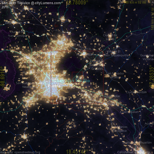
Analysis of San Juan Tepulco night lights 2016
Square area 10x10 km:
 0.65%
0.65%90-99
0.43%80-89
5.19%70-79
4.11%60-69
3.68%50-59
1.73%40-49
7.36%30-39
4.98%20-29
19.48%10-19
23.59%0-9
28.79%Square area 50x50 km:
5.37%90-99
4.82%80-89
8.95%70-79
6.3%60-69
4.96%50-59
3.83%40-49
7.44%30-39
6.59%20-29
8.24%10-19
17.31%0-9
26.19%Clear (daylight) street map image can be seen on geolist.org.
Map coordinates:
19° 46' 48.3" North, 98° 41' 29.8" West
19° 7' 1.5" North, 97° 59' 18.5" West
18° 27' 5.1" North, 97° 17' 7.3" West
Some cities around San Juan Tepulco sort by population:
• Amozoc de Mota
9.9 km =6.2 mi,  216°
216°
• Acajete
3.8 km =2.4 mi,  99°
99°
• Tepatlaxco de Hidalgo
4.3 km =2.7 mi,  158°
158°
• San Miguel Canoa
12.6 km =7.8 mi,  287°
287°
• Santa María Xonacatepec
12.5 km =7.8 mi,  255°
255°
• La Magdalena Tetela Morelos
9 km =5.6 mi,  146°
146°
• San Agustín Tlaxco
6.8 km =4.2 mi,  182°
182°
• El Rincón Citlaltépetl
10.8 km =6.7 mi,  66°
66°
3515806 (p: 8,232)
Sources (retrieved 2019-11-25):
» Earth at Night: Flat Maps 2012, 2016