Rancho Alegre [Fraccionamiento] night lights from space
Night Light of Rancho Alegre [Fraccionamiento] (Jalisco) from space (Mexico) Src. Average luminocity for 10x10km area is 76.053% and for 50x50km: 44.4117%.
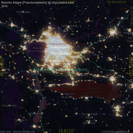
Analysis of Rancho Alegre [Fraccionamiento] night lights 2016
Square area 10x10 km:
 9.28%
9.28%90-99
11.93%80-89
21.59%70-79
27.27%60-69
12.12%50-59
9.85%40-49
5.49%30-39
2.46%20-29
0%10-19
0%0-9
0%Square area 50x50 km:
12.36%90-99
8.01%80-89
8.26%70-79
6.19%60-69
4.26%50-59
3.91%40-49
5.24%30-39
4.33%20-29
5.62%10-19
10.76%0-9
31.06%Clear (daylight) street map image can be seen on geolist.org.
Map coordinates:
21° 7' 51.2" North, 103° 57' 39.3" West
20° 28' 25" North, 103° 15' 28" West
19° 48' 48.6" North, 102° 33' 16.8" West
Some cities around Rancho Alegre [Fraccionamiento] sort by population:
• El Salto
9.4 km =5.8 mi,  57°
57°
• El Quince
8.3 km =5.2 mi,  340°
340°
• San José del Castillo
4.9 km =3 mi,  24°
24°
• Galaxia Bonito Jalisco
6.5 km =4 mi, 57°
• La Alameda
2.6 km =1.6 mi, 22°
• Capulín
1.3 km =0.8 mi,  291°
291°
• Los Olivos
4.4 km =2.7 mi,  151°
151°
• Cajititlán
7.1 km =4.4 mi,  229°
229°
8858179 (p: 8,441)
Sources (retrieved 2019-11-25):
» Earth at Night: Flat Maps 2012, 2016