El Quince night lights from space
Night Light of El Quince (Jalisco) from space (Mexico) Src. Average luminocity for 10x10km area is 88.4242% and for 50x50km: 50.4493%.
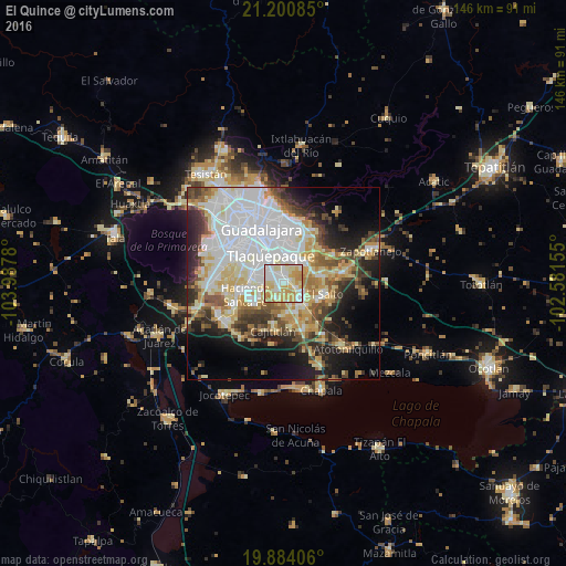
Analysis of El Quince night lights 2016
Square area 10x10 km:
 24.24%
90-99
25.38%80-89
22.54%70-79
23.3%60-69
4.36%50-59
0.19%40-49
0%30-39
0%20-29
0%10-19
0%0-9
0%Square area 50x50 km:
15.7%90-99
9.67%80-89
8.53%70-79
6.35%60-69
4.07%50-59
4.48%40-49
5.57%30-39
5.32%20-29
7.19%10-19
10.92%0-9
22.2%Clear (daylight) street map image can be seen on geolist.org.
Map coordinates:
21° 12' 3.1" North, 103° 59' 16.1" West
20° 32' 37.9" North, 103° 17' 4.8" West
19° 53' 2.6" North, 102° 34' 53.6" West
Some cities around El Quince sort by population:
• Las Pintitas
2.9 km =1.8 mi,  321°
321°
• Las Pintas de Arriba
5.2 km =3.2 mi,  309°
309°
• San José del Castillo
5.9 km =3.7 mi,  124°
124°
• Valle Dorado Inn
8.3 km =5.2 mi,  254°
254°
• La Alameda
6.6 km =4.1 mi,  144°
144°
• Capulín
7.5 km =4.7 mi,  167°
167°
• Rancho Alegre [Fraccionamiento]
8.3 km =5.2 mi,  160°
160°
• El Verde
1.4 km =0.9 mi,  24°
24°
4008224 (p: 17,669)
Sources (retrieved 2019-11-25):
» Earth at Night: Flat Maps 2012, 2016