Paso del Macho night lights from space
Night Light of Paso del Macho (Veracruz) from space (Mexico) Src. Average luminocity for 10x10km area is 7.3074% and for 50x50km: 6.3948%.
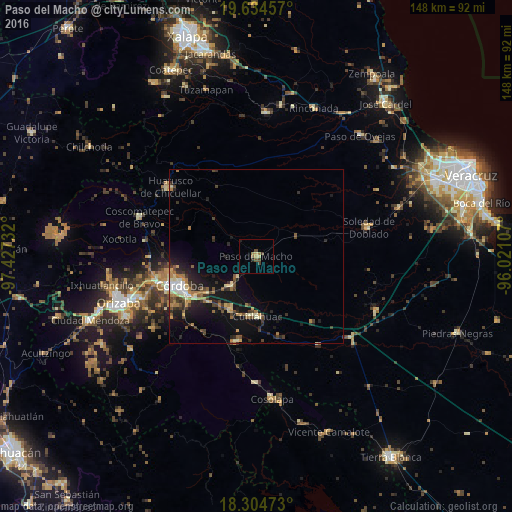
Analysis of Paso del Macho night lights 2016
Square area 10x10 km:
 0%
0%90-99
0.22%80-89
1.52%70-79
0.87%60-69
1.73%50-59
1.52%40-49
2.6%30-39
1.08%20-29
1.3%10-19
0.43%0-9
88.74%Square area 50x50 km:
0.37%90-99
0.7%80-89
0.91%70-79
0.77%60-69
1.1%50-59
0.84%40-49
1.25%30-39
1.2%20-29
1.93%10-19
5.37%0-9
85.57%Clear (daylight) street map image can be seen on geolist.org.
Map coordinates:
19° 38' 4.5" North, 97° 25' 38.4" West
18° 58' 15.5" North, 96° 43' 27.1" West
18° 18' 17" North, 96° 1' 15.9" West
Some cities around Paso del Macho sort by population:
• Córdoba
23.3 km =14.5 mi,  245°
245°
• General Miguel Alemán
11.2 km =7 mi,  219°
219°
• Cuitláhuac
17.4 km =10.8 mi,  179°
179°
• Córdoba (Santa Leticia)
27.7 km =17.2 mi,  255°
255°
• Amatlán de los Reyes
24.5 km =15.2 mi,  235°
235°
• El Pueblito
27.5 km =17.1 mi, 249°
• Yanga
17.2 km =10.7 mi,  206°
206°
• Peñuela
21.4 km =13.3 mi, 236°
3521833 (p: 13,413)
Sources (retrieved 2019-11-25):
» Earth at Night: Flat Maps 2012, 2016