Córdoba (Santa Leticia) night lights from space
Night Light of Córdoba (Santa Leticia) (Veracruz) from space (Mexico) Src. Average luminocity for 10x10km area is 64.6948% and for 50x50km: 16.5823%.
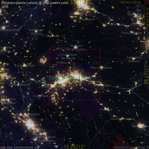
Analysis of Córdoba (Santa Leticia) night lights 2016
Square area 10x10 km:
 9.52%
9.52%90-99
14.07%80-89
7.58%70-79
10.39%60-69
20.35%50-59
6.49%40-49
11.04%30-39
10.82%20-29
7.58%10-19
2.16%0-9
0%Square area 50x50 km:
1.24%90-99
1.98%80-89
2.05%70-79
2.24%60-69
3.36%50-59
2.04%40-49
3.48%30-39
3.36%20-29
5.16%10-19
12.73%0-9
62.35%Clear (daylight) street map image can be seen on geolist.org.
Map coordinates:
19° 34' 20.9" North, 97° 40' 55.3" West
18° 54' 31" North, 96° 58' 44" West
18° 14' 31.6" North, 96° 16' 32.8" West
Some cities around Córdoba (Santa Leticia) sort by population:
• Ixtaczoquitlán
10.7 km =6.6 mi,  235°
235°
• Fortín de las Flores
2.2 km =1.4 mi,  268°
268°
• Amatlán de los Reyes
9.6 km =6 mi,  136°
136°
• Atzacan
11 km =6.8 mi, 269°
• El Pueblito
2.7 km =1.7 mi,  158°
158°
• Cuautlapán
5.8 km =3.6 mi,  233°
233°
• Monte Blanco
7.6 km =4.7 mi,  328°
328°
• Peñuela
10.3 km =6.4 mi,  118°
118°
8858140 (p: 11,720)
Sources (retrieved 2019-11-25):
» Earth at Night: Flat Maps 2012, 2016