Peñuela night lights from space
Night Light of Peñuela (Veracruz) from space (Mexico) Src. Average luminocity for 10x10km area is 44.5736% and for 50x50km: 14.2412%.
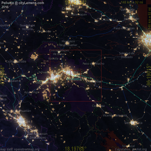
Analysis of Peñuela night lights 2016
Square area 10x10 km:
 4.55%
4.55%90-99
7.36%80-89
6.71%70-79
6.93%60-69
8.66%50-59
5.41%40-49
5.84%30-39
9.52%20-29
13.85%10-19
30.09%0-9
1.08%Square area 50x50 km:
1.11%90-99
1.83%80-89
1.89%70-79
1.89%60-69
2.67%50-59
1.75%40-49
3.03%30-39
2.98%20-29
4.06%10-19
9%0-9
69.78%Clear (daylight) street map image can be seen on geolist.org.
Map coordinates:
19° 31' 42" North, 97° 35' 47" West
18° 51' 51.6" North, 96° 53' 35.8" West
18° 11' 51.6" North, 96° 11' 24.5" West
Some cities around Peñuela sort by population:
• Córdoba
4.1 km =2.5 mi,  303°
303°
• Fortín de las Flores
12.2 km =7.6 mi,  293°
293°
• General Miguel Alemán
11.1 km =6.9 mi,  73°
73°
• Córdoba (Santa Leticia)
10.3 km =6.4 mi, 298°
• Amatlán de los Reyes
3.1 km =1.9 mi,  230°
230°
• El Pueblito
8.4 km =5.2 mi, 287°
• Cuautlapán
13.7 km =8.5 mi,  276°
276°
• Yanga
10.6 km =6.6 mi,  109°
109°
3823816 (p: 5,421)
Sources (retrieved 2019-11-25):
» Earth at Night: Flat Maps 2012, 2016