El Pueblito night lights from space
Night Light of El Pueblito (Veracruz) from space (Mexico) Src. Average luminocity for 10x10km area is 68.5195% and for 50x50km: 16.7829%.
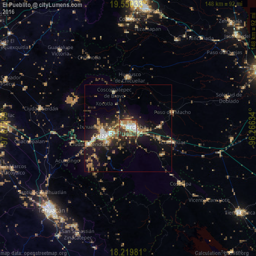
Analysis of El Pueblito night lights 2016
Square area 10x10 km:
 12.34%
90-99
17.97%80-89
7.36%70-79
7.36%60-69
21.86%50-59
3.46%40-49
11.69%30-39
14.94%20-29
3.03%10-19
0%0-9
0%Square area 50x50 km:
1.24%90-99
2.01%80-89
2.1%70-79
2.3%60-69
3.43%50-59
2.17%40-49
3.52%30-39
3.33%20-29
5.04%10-19
12.52%0-9
62.35%Clear (daylight) street map image can be seen on geolist.org.
Map coordinates:
19° 33' 1.2" North, 97° 40' 21.3" West
18° 53' 11" North, 96° 58' 10.1" West
18° 13' 11.3" North, 96° 15' 58.8" West
Some cities around El Pueblito sort by population:
• Córdoba
4.6 km =2.9 mi,  93°
93°
• Ixtaczoquitlán
10.4 km =6.5 mi,  249°
249°
• Fortín de las Flores
4 km =2.5 mi,  306°
306°
• Córdoba (Santa Leticia)
2.7 km =1.7 mi,  338°
338°
• Amatlán de los Reyes
7.2 km =4.5 mi,  128°
128°
• Cuautlapán
5.7 km =3.5 mi,  259°
259°
• Monte Blanco
10.2 km =6.3 mi,  330°
330°
• Peñuela
8.4 km =5.2 mi,  107°
107°
11584022 (p: 8,078)
Sources (retrieved 2019-11-25):
» Earth at Night: Flat Maps 2012, 2016