Mocorito night lights from space
Night Light of Mocorito (Sinaloa) from space (Mexico) Src. Average luminocity for 10x10km area is 6.3909% and for 50x50km: 3.3278%.
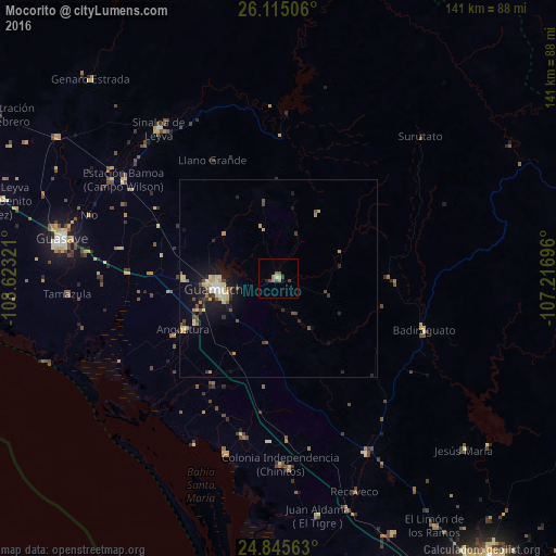
Analysis of Mocorito night lights 2016
Square area 10x10 km:
 0.4%
0.4%90-99
0.4%80-89
0.79%70-79
0.6%60-69
1.98%50-59
1.98%40-49
0.99%30-39
1.59%20-29
0.79%10-19
0%0-9
90.48%Square area 50x50 km:
0.21%90-99
0.29%80-89
0.73%70-79
0.52%60-69
0.28%50-59
0.51%40-49
0.5%30-39
0.37%20-29
0.67%10-19
2.92%0-9
93%Clear (daylight) street map image can be seen on geolist.org.
Map coordinates:
26° 6' 54.2" North, 108° 37' 23.6" West
25° 28' 55.3" North, 107° 55' 12.3" West
24° 50' 44.3" North, 107° 13' 1.1" West
Some cities around Mocorito sort by population:
• Guasave
55.7 km =34.6 mi,  279°
279°
• Guamúchil
16 km =9.9 mi,  260°
260°
• La Reforma
46.6 km =29 mi,  197°
197°
• Estacion Bamoa
46.8 km =29.1 mi,  302°
302°
• Pericos
49.8 km =30.9 mi,  153°
153°
• Naranjo
66.8 km =41.5 mi, 302°
• Sinaloa de Leyva
48.5 km =30.1 mi,  321°
321°
• Angostura
27.4 km =17 mi,  241°
241°
3995652 (p: 5,426)
Sources (retrieved 2019-11-25):
» Earth at Night: Flat Maps 2012, 2016