La Reforma night lights from space
Night Light of La Reforma (Sinaloa) from space (Mexico) Src. Average luminocity for 10x10km area is 4.6553% and for 50x50km: 1.1243%.
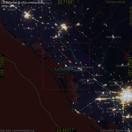
Analysis of La Reforma night lights 2016
Square area 10x10 km:
 0%
0%90-99
0.19%80-89
0.95%70-79
0.76%60-69
2.27%50-59
0.76%40-49
0.76%30-39
0.76%20-29
0%10-19
0%0-9
93.56%Square area 50x50 km:
0%90-99
0.05%80-89
0.22%70-79
0.08%60-69
0.31%50-59
0.21%40-49
0.37%30-39
0.35%20-29
0.16%10-19
0.05%0-9
98.2%Clear (daylight) street map image can be seen on geolist.org.
Map coordinates:
25° 43' 0.5" North, 108° 45' 35.5" West
25° 4' 53.9" North, 108° 3' 24.2" West
24° 26' 35.4" North, 107° 21' 13" West
Some cities around La Reforma sort by population:
• Guasave
68 km =42.3 mi,  322°
322°
• Guamúchil
42 km =26.1 mi,  357°
357°
• Navolato
50.1 km =31.1 mi,  134°
134°
• General Ángel Flores (La Palma)
49.8 km =30.9 mi, 125°
• Pericos
36 km =22.4 mi,  90°
90°
• Adolfo López Mateos (El Tamarindo)
47.4 km =29.5 mi,  115°
115°
• Mocorito
46.6 km =29 mi,  17°
17°
• Angostura
33.3 km =20.7 mi,  341°
341°
4000490 (p: 6,743)
Sources (retrieved 2019-11-25):
» Earth at Night: Flat Maps 2012, 2016