Mazatecochco night lights from space
Night Light of Mazatecochco (Tlaxcala) from space (Mexico) Src. Average luminocity for 10x10km area is 66.2987% and for 50x50km: 55.6312%.
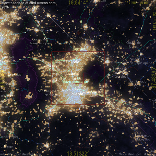
Analysis of Mazatecochco night lights 2016
Square area 10x10 km:
 2.16%
2.16%90-99
11.47%80-89
23.81%70-79
16.02%60-69
8.66%50-59
8.87%40-49
13.42%30-39
9.31%20-29
6.28%10-19
0%0-9
0%Square area 50x50 km:
9.89%90-99
8.08%80-89
14.61%70-79
10.7%60-69
7.29%50-59
7.44%40-49
8.43%30-39
4.81%20-29
6.87%10-19
9.5%0-9
12.37%Clear (daylight) street map image can be seen on geolist.org.
Map coordinates:
19° 50' 29" North, 98° 53' 23.6" West
19° 10' 43.1" North, 98° 11' 12.4" West
18° 30' 47.6" North, 97° 29' 1.1" West
Some cities around Mazatecochco sort by population:
• Villa Vicente Guerrero
6.8 km =4.2 mi,  160°
160°
• Zacatelco
6.9 km =4.3 mi,  306°
306°
• Papalotla
2.1 km =1.3 mi,  238°
238°
• Teolocholco
7.2 km =4.5 mi,  356°
356°
• Almecatla
6.5 km =4 mi,  232°
232°
• Xicohtzinco
5 km =3.1 mi,  263°
263°
• Tenancingo
3.8 km =2.4 mi,  203°
203°
• Santa Catarina Ayometla
3.6 km =2.2 mi, 307°
3523416 (p: 9,671)
Sources (retrieved 2019-11-25):
» Earth at Night: Flat Maps 2012, 2016