Las Jarretaderas night lights from space
Night Light of Las Jarretaderas (Nayarit) from space (Mexico) Src. Average luminocity for 10x10km area is 55.3011% and for 50x50km: 8.6763%.
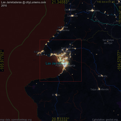
Analysis of Las Jarretaderas night lights 2016
Square area 10x10 km:
 5.3%
5.3%90-99
8.71%80-89
13.64%70-79
14.2%60-69
8.9%50-59
6.25%40-49
7.2%30-39
8.14%20-29
10.04%10-19
13.07%0-9
4.55%Square area 50x50 km:
0.64%90-99
0.96%80-89
1.68%70-79
1.83%60-69
1.2%50-59
0.83%40-49
1.48%30-39
1.32%20-29
2.44%10-19
5.6%0-9
82.03%Clear (daylight) street map image can be seen on geolist.org.
Map coordinates:
21° 20' 55.8" North, 105° 58' 37.3" West
20° 41' 33" North, 105° 16' 26" West
20° 1' 60" North, 104° 34' 14.8" West
Some cities around Las Jarretaderas sort by population:
• Puerto Vallarta
9.5 km =5.9 mi,  151°
151°
• Ixtapa
7.7 km =4.8 mi,  69°
69°
• San José del Valle
9.2 km =5.7 mi,  30°
30°
• Mezcales
4.3 km =2.7 mi,  348°
348°
• San Vicente
6.7 km =4.2 mi,  21°
21°
• Bucerías
9.5 km =5.9 mi,  318°
318°
• Valle de Banderas
13.1 km =8.1 mi,  11°
11°
• El Porvenir
7.6 km =4.7 mi, 25°
4029337 (p: 6,262)
Sources (retrieved 2019-11-25):
» Earth at Night: Flat Maps 2012, 2016