La Trinitaria night lights from space
Night Light of La Trinitaria (Chiapas) from space (Mexico) Src. Average luminocity for 10x10km area is 9.3017% and for 50x50km: 5.8902%.
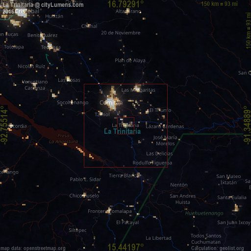
Analysis of La Trinitaria night lights 2016
Square area 10x10 km:
 0.21%
0.21%90-99
0.62%80-89
0%70-79
2.69%60-69
0.62%50-59
1.03%40-49
5.17%30-39
2.69%20-29
1.03%10-19
0.83%0-9
85.12%Square area 50x50 km:
0.4%90-99
0.83%80-89
0.64%70-79
1.06%60-69
0.66%50-59
0.44%40-49
1.23%30-39
1.19%20-29
1.42%10-19
3.91%0-9
88.22%Clear (daylight) street map image can be seen on geolist.org.
Map coordinates:
16° 47' 34.5" North, 92° 45' 18.5" West
16° 7' 6.9" North, 92° 3' 7.2" West
15° 26' 31.1" North, 91° 20' 56" West
Some cities around La Trinitaria sort by population:
• Comitán
16.8 km =10.4 mi,  328°
328°
• Las Margaritas
22.9 km =14.2 mi,  19°
19°
• Las Rosas
43.7 km =27.2 mi,  308°
308°
• San Francisco Pujiltic
46.4 km =28.8 mi,  292°
292°
• Chicomuselo
48.4 km =30.1 mi,  210°
210°
• El Triunfo
22.6 km =14 mi,  65°
65°
• Tzimol
16.3 km =10.1 mi,  296°
296°
• Venustiano Carranza
15.5 km =9.6 mi,  59°
59°
3524527 (p: 9,042)
Sources (retrieved 2019-11-25):
» Earth at Night: Flat Maps 2012, 2016