Chicomuselo night lights from space
Night Light of Chicomuselo (Chiapas) from space (Mexico) Src. Average luminocity for 10x10km area is 4.5606% and for 50x50km: 0.7508%.
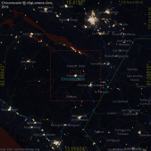
Analysis of Chicomuselo night lights 2016
Square area 10x10 km:
 0%
0%90-99
0.87%80-89
0.87%70-79
0%60-69
1.73%50-59
0.87%40-49
0.22%30-39
1.52%20-29
0.87%10-19
0%0-9
93.07%Square area 50x50 km:
0%90-99
0.1%80-89
0.03%70-79
0.24%60-69
0.11%50-59
0.12%40-49
0.18%30-39
0.2%20-29
0.13%10-19
0.1%0-9
98.8%Clear (daylight) street map image can be seen on geolist.org.
Map coordinates:
16° 25' 11.3" North, 92° 59' 11.1" West
15° 44' 39.1" North, 92° 16' 59.9" West
15° 3' 58.8" North, 91° 34' 48.6" West
Some cities around Chicomuselo sort by population:
• Comitán
58.1 km =36.1 mi,  15°
15°
• Motozintla
42.1 km =26.2 mi,  174°
174°
• Comalapa
17.8 km =11.1 mi,  122°
122°
• Jaltenango de la Paz
49.3 km =30.6 mi,  286°
286°
• La Trinitaria
48.4 km =30.1 mi,  30°
30°
• La Libertad, GT
51.2 km =31.8 mi, 119°
• San Antonio Huista, GT
55.8 km =34.7 mi,  100°
100°
• Tzimol
49.9 km =31 mi,  11°
11°
3530935 (p: 5,938)
Sources (retrieved 2019-11-25):
» Earth at Night: Flat Maps 2012, 2016