El Triunfo night lights from space
Night Light of El Triunfo (Chiapas) from space (Mexico) Src. Average luminocity for 10x10km area is 3.0475% and for 50x50km: 2.7509%.
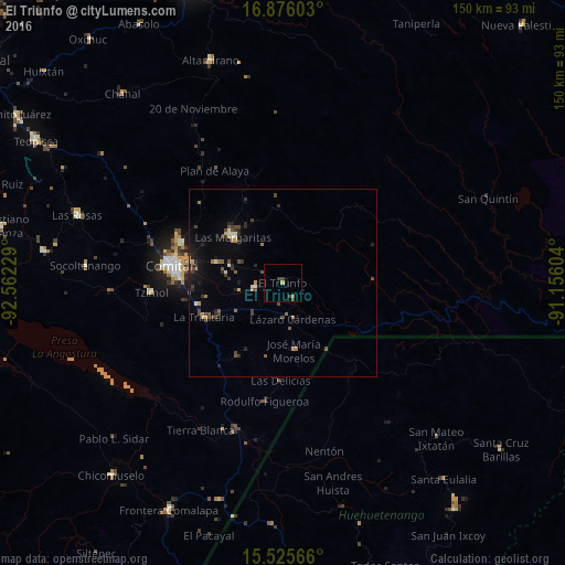
Analysis of El Triunfo night lights 2016
Square area 10x10 km:
 0%
0%90-99
0%80-89
0%70-79
0.83%60-69
0.83%50-59
0%40-49
1.03%30-39
2.27%20-29
0%10-19
0%0-9
95.04%Square area 50x50 km:
0.06%90-99
0.24%80-89
0.17%70-79
0.34%60-69
0.39%50-59
0.28%40-49
0.89%30-39
0.74%20-29
0.73%10-19
1.41%0-9
94.77%Clear (daylight) street map image can be seen on geolist.org.
Map coordinates:
16° 52' 33.7" North, 92° 33' 44.2" West
16° 12' 7.2" North, 91° 51' 33" West
15° 31' 32.4" North, 91° 9' 21.7" West
Some cities around El Triunfo sort by population:
• Comitán
29.9 km =18.6 mi,  279°
279°
• Jacaltenango, GT
61.6 km =38.3 mi,  165°
165°
• Las Margaritas
17.9 km =11.1 mi,  313°
313°
• Las Rosas
57.5 km =35.7 mi,  288°
288°
• San Mateo Ixtatán, GT
57.9 km =36 mi,  135°
135°
• La Trinitaria
22.6 km =14 mi,  245°
245°
• Tzimol
35.3 km =21.9 mi,  266°
266°
• Venustiano Carranza
7.4 km =4.6 mi,  259°
259°
3816465 (p: 5,478)
Sources (retrieved 2019-11-25):
» Earth at Night: Flat Maps 2012, 2016